Aley District
Aalay District | |
|---|---|
District | |
| عاليه | |
 Aley District | |
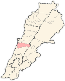
 Location in Lebanon | |
| Country | |
| Governorate | Mount Lebanon Governorate |
| Capital | Aley |
| Area | |
• Total | 102 sq mi (264 km2) |
| Population | |
• Estimate (31 December 2017) | 196,282 |
| Time zone | UTC+2 (EST) |
| • Summer (DST) | +3 |
Aley (Arabic: عاليه) is a district (qadaa) in Mount Lebanon, Lebanon, to the south-east of the Lebanon's capital Beirut. The capital is Aley. Aley city was previously known as the "bride of the summers" during the 1960 and 1970s, when Aley and neighboring Bhamdoune were attractive tourist locations for Lebanese emigres and local Lebanese
The district elects 5 members of parliament, of which 3 are Christians (1 Orthodox and 2 Maronite) and 2 are Druze. During the 1975-1990 Civil War in Lebanon, Aley witnessed several battles around its environs.

Cities
[edit]- Abey
- Aghmid
- Ain Dara
- Aïn-El-Jdeidé
- Aïn-Enoub
- Aïn-Rommané
- Aïn Drafile
- Aïn El-Halzoune
- Aïn Ksour
- Ain Saideh
- Aïn Sofar
- Aïn Traz
- Aïnab
- Aïtate
- Aley
- Aramoun
- Baïssour
- Baouarta
- Bchamoune
- Bdédoune
- Bedghane
- Bhamdoun
- Bhouara
- Bisrine
- Bkhichtay
- Bleibel
- Bmakkine
- Bmehraï
- Bouzridé
- Bsous
- Btallaoun
- Btater
- Bteezanieh
- Chamlane
- Chanay
- Sharoun
- Chartoun
- Chouaifat Amroussyat
- Chouaifat Oumara
- Chouaifat Qobbat
- Dakkoun
- Deir-Koubel
- Dfoun
- Douair El-Roummane
- EL-Azouniyeh
- El-Bennayé
- El-Fsaïkine
- El-Ghaboun
- El-Kahalé
- El-Kamatiyeh
- El-Mansouriyeh et Aïn-El-Marge
- El-Mechrefeh
- El-Mreijate
- El-Ramliyeh
- El-Rejmeh
- Habramoun
- Houmale
- Kaïfoun
- Kfar-Aammay
- Kfar Matta
- litige
- Maasraïti
- Majdel Baana-Sawfar
- Mazraet El-Nahr
- Mchakhté
- Mejdlaya
- Rechmaya
- Remhala
- Roueissat El-Naaman
- Saoufar
- Sarahmoul
- Selfaya
- Souk-El-Gharb
- Taazanieh
Demographics
[edit]Like the neighboring Chouf District, the Aley district is also one of the most religiously diverse areas in Lebanon. The largest religious community in the Aley district is the Druze denomination, followed by the Maronite, and Greek Orthodox Christian denominations. There are also small communities of Shia Muslims. As of 2022, the religious make-up of the District's 133,939 voters were roughly 54% Druze, 22% Maronite Catholics, 11% Greek Orthodox, 4% Greek Catholic, 4% Shia, and 5% others.
References
[edit]External links
[edit]- Kahale
- Bsous Archived 2020-12-04 at the Wayback Machine

