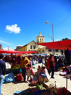
Achacachi
Achacachi
Jach'ak'achi | |
|---|---|
 Market in Achacachi | |
| Coordinates: 16°02′40″S 68°41′06″W / 16.04444°S 68.68500°W | |
| Country | |
| Admin. division | La Paz Department |
| Province | Omasuyos Province |
| Municipality | Achacachi Municipality |
| Elevation | 3,854 m (12,644 ft) |
| Population (2012 census) | |
• Total | 8,857 |
| • Ethnicities | Aymara |
| Time zone | UTC-4 (BOT) |
| Area code | (+591) 2 |
| Climate | ET |
| Website | www |
Achacachi is a town on the Altiplano plateau in the South American Andes in the La Paz Department in Bolivia. It is the capital of the Omasuyos Province.
History of Achacachi
[edit]Achacachi, as an establishment, existed before the arrival of the Spaniards, as shown by descriptions that were made on "cronicas" and "relaciones" (official papers written by authorities) by royal or ecclesiastical Spanish authorities.[citation needed] Achacachi was the capital of a colla "señorio" called Pacasa, in the "Umasuyus" (from Aymara: "shore side") region, which was located alongside the East of Lake Intikjarka (Titicaca) in the Peru-Bolivian plateau.
Location
[edit]Achacachi is at an elevation of 3,854 m or 12.647 feet amsl on the Achacachi peninsula on the eastern shores of Lake Titicaca, 96 km (60 mi) northwest of the capital La Paz.
Notable people
[edit]- Juan Vargas Aruquipa, Catholic Bishop of Coroico
Partner city
[edit]16°02′40″S 68°41′06″W / 16.04444°S 68.68500°W
Climate
[edit]| Climate data for Achacachi (Belen), elevation 3,833 m (12,575 ft) | |||||||||||||
|---|---|---|---|---|---|---|---|---|---|---|---|---|---|
| Month | Jan | Feb | Mar | Apr | May | Jun | Jul | Aug | Sep | Oct | Nov | Dec | Year |
| Mean daily maximum °C (°F) | 14.5 (58.1) |
14.6 (58.3) |
15.0 (59.0) |
15.3 (59.5) |
14.8 (58.6) |
13.7 (56.7) |
13.4 (56.1) |
14.2 (57.6) |
14.6 (58.3) |
15.8 (60.4) |
15.9 (60.6) |
15.3 (59.5) |
14.8 (58.6) |
| Daily mean °C (°F) | 9.0 (48.2) |
9.0 (48.2) |
8.8 (47.8) |
7.6 (45.7) |
5.5 (41.9) |
3.9 (39.0) |
3.6 (38.5) |
4.9 (40.8) |
6.7 (44.1) |
8.2 (46.8) |
8.7 (47.7) |
9.2 (48.6) |
7.1 (44.8) |
| Mean daily minimum °C (°F) | 3.6 (38.5) |
3.4 (38.1) |
2.7 (36.9) |
0.0 (32.0) |
−3.8 (25.2) |
−5.9 (21.4) |
−6.1 (21.0) |
−4.4 (24.1) |
−1.2 (29.8) |
0.6 (33.1) |
1.5 (34.7) |
3.1 (37.6) |
−0.5 (31.0) |
| Average precipitation mm (inches) | 96.7 (3.81) |
72.2 (2.84) |
58.5 (2.30) |
22.3 (0.88) |
15.7 (0.62) |
8.0 (0.31) |
6.5 (0.26) |
11.2 (0.44) |
22.3 (0.88) |
31.2 (1.23) |
42.0 (1.65) |
74.0 (2.91) |
460.6 (18.13) |
| Average precipitation days | 16.8 | 13.6 | 11.1 | 5.6 | 3.9 | 2.0 | 1.9 | 2.6 | 5.7 | 6.8 | 8.2 | 13 | 91.2 |
| Average relative humidity (%) | 76.9 | 77.3 | 76.6 | 70.2 | 62.1 | 60.9 | 60.4 | 61.7 | 64.2 | 64.8 | 66.9 | 71.8 | 67.8 |
| Source: Servicio Nacional de Meteorología e Hidrología de Bolivia[1][2] | |||||||||||||
References
[edit]- ^ "Base de datos Sistema Meteorológico–SISMET" (in Spanish). Servicio Nacional de Meteorología e Hidrología de Bolivia. Archived from the original on 7 June 2018. Retrieved 12 June 2024.
- ^ "índices climáticos para 149 estaciones meteorológicas en Bolivia" (in Spanish). Servicio Nacional de Meteorología e Hidrología de Bolivia. Retrieved 12 June 2024.
- www.ine.gov.bo


