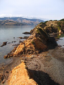
Ōnawe Peninsula
Appearance
Ōnawe | |
|---|---|
former pā (fortified Māori village) | |
 Ōnawe Peninsula, 2007 | |
| Coordinates: 43°46′26″S 172°55′30″E / 43.774°S 172.925°E | |
| Country | New Zealand |

The Ōnawe Peninsula is a volcanic plug inside Akaroa Harbour, on Banks Peninsula in Canterbury, New Zealand. It is the site of a former pā (a Māori village). It is part of the Banks Peninsula Volcano.
The New Zealand Ministry for Culture and Heritage explains that the name Ōnawe is made up of "Ō" meaning "place of" and "nawe" meaning "to set on fire".[1]
It was the site of a Ngāi Tahu pā captured by Te Rauparaha, chief of the Ngāti Toa in 1831.[2] Up to 1,200 people were killed here, and the land is sacred to Ngāi Tahu[3] so "is deemed to be vested in Te Runanga o Ngāi Tahu" as part of the Ngāi Tahu Waitangi claims settlement in 1998.[4]
The peninsula is only accessible at low tide; at high tide, the peninsula becomes an island.[5]
Wikimedia Commons has media related to Ōnawe Peninsula.
References
[edit]- ^ "1000 Māori place names". New Zealand Ministry for Culture and Heritage. 6 August 2019.
- ^ "Ōnawe Pa", Christchurch City Libraries website
- ^ "Ōnawe Pā - Draft Management Plan", Ngai Tahu website
- ^ "Ngai Tahu Claims Settlement Act 1998"
- ^ History Hit


