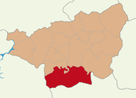
Çınar, Diyarbakır
Appearance
Çınar | |
|---|---|
District and municipality | |
 | |
 Map showing Çınar District in Diyarbakır Province | |
| Coordinates: 37°43′27″N 40°24′54″E / 37.72417°N 40.41500°E | |
| Country | Turkey |
| Province | Diyarbakır |
| Government | |
| • Mayor | Bedri Kaya (HDP) |
Area | 1,934 km2 (747 sq mi) |
| Population (2022)[1] | 76,966 |
| • Density | 40/km2 (100/sq mi) |
| Time zone | UTC+3 (TRT) |
| Postal code | 21750 |
| Area code | 0412 |
| Website | www |
Çınar (Kurdish: Çinar/Axpar)[2] is a municipality and district of Diyarbakır Province, Turkey.[3] Its area is 1,934 km2,[4] and its population is 76,966 (2022).[1]
In the local elections 2019 Bedri Kaya was elected Mayor.[5] Muhammed Fatih Günlü was appointed District Governor in 2022.[6]
The historic ruined Zerzevan Castle is located 13 km (8.1 mi) southeast of Çınar town.[7]
Composition
[edit]There are 101 neighbourhoods in Çınar District:[8]
- Ağaçsever
- Akçomak
- Aktepe
- Alabaş
- Alancık
- Altınakar
- Arafat
- Aşağıkonak
- Aşağımollaali
- Avdalı
- Ayveri
- Bağacık
- Ballıbaba
- Başaklı
- Başalan
- Bayırkonağı
- Belenli
- Bellitaş
- Beneklitaş
- Beşpınar
- Bilmece
- Boğazören
- Bozçalı
- Bulutçeker
- Çakırkaya
- Çakırtutmaz
- Çataltarla
- Çatmadal
- Çeltikaltı
- Çınarköy
- Çömçeli
- Çukurbaşı
- Cumhuriyet
- Demirölçek
- Dikmencik
- Dişlibaşak
- Düğrük
- Düzova
- Ekinveren
- Eski
- Fatih
- Filizören
- Gazi
- Göktepe
- Görece
- Gümüştaş
- Gürses
- Halıören
- Halkapınar
- Harabe
- Hasköy
- Höyükdibi
- İnanöz
- İncirtepe
- Karababa
- Karabudak
- Karaçevre
- Karalar
- Karasungur
- Kazıktepe
- Kılıçkaya
- Kırkağaç
- Köksalan
- Kubacık
- Kürekli
- Kuruyazı
- Kutluk
- Kuyuluhöyük
- Leblebitaş
- Meydanköy
- Muratcık
- Öncülü
- Ortaşar
- Ovabağ
- Özyar
- Pembeviran
- Piremehmetağa
- Şekerören
- Selyazı
- Sevindik
- Şeyhçoban
- Sırımkesen
- Soğansuyu
- Solmaz
- Şükürlü
- Sürendal
- Taşhelvası
- Tekkaynak
- Tilver
- Toraman
- Uzgider
- Yaprakbaşı
- Yarımkaş
- Yazçiçeği
- Yeni
- Yeşil
- Yeşilbağ
- Yeşiltaş
- Yıllarca
- Yukarıortaören
- Yuvacık
References
[edit]- ^ a b "Address-based population registration system (ADNKS) results dated 31 December 2022, Favorite Reports" (XLS). TÜİK. Retrieved 12 July 2023.
- ^ Adem Avcıkıran (2009). Kürtçe Anamnez Anamneza bi Kurmancî (PDF) (in Turkish and Kurdish). p. 55. Retrieved 17 December 2019.
- ^ Büyükşehir İlçe Belediyesi, Turkey Civil Administration Departments Inventory. Retrieved 12 July 2023.
- ^ "İl ve İlçe Yüz ölçümleri". General Directorate of Mapping. Retrieved 12 July 2023.
- ^ "Diyarbakır Çınar Seçim Sonuçları - 31 Mart 2019 Yerel Seçimleri". www.sabah.com.tr. Retrieved 10 November 2019.
- ^ "Muhammed Fatih GÜNLÜ". Çınar Kaymakamlığı. Retrieved 27 August 2023.
- ^ Kaya, Selim (December 2014). "Zerzevan Kalesi". Atlas (in Turkish) (261). Retrieved 29 April 2018.
- ^ Mahalle, Turkey Civil Administration Departments Inventory. Retrieved 12 July 2023.


