Zwettl
Zwettl
Zwedl | |
|---|---|
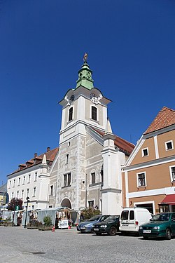
 Old Town Hall | |
| Coordinates: 48°36′12″N 15°10′08″E / 48.60333°N 15.16889°E | |
| Country | Austria |
| State | Lower Austria |
| District | Zwettl |
| Government | |
| • Mayor | Franz Mold (ÖVP) |
| Area | |
• Total | 256.31 km2 (98.96 sq mi) |
| Elevation | 520 m (1,710 ft) |
| Population (2018-01-01)[2] | |
• Total | 10,908 |
| • Density | 43/km2 (110/sq mi) |
| Time zone | UTC+1 (CET) |
| • Summer (DST) | UTC+2 (CEST) |
| Postal code | 3910 |
| Area code | 02822 |
| Vehicle registration | ZT |
| Website | www.zwettl.gv.at |
Zwettl (German pronunciation: [ˈt͡svɛtl̩]; Central Bavarian: Zwedl; Czech: Světlá) is a town and district capital of the Austrian state of Lower Austria. It is chiefly known as the location of Zwettl Abbey, first mentioned in October 1139.
History
[edit]
The name originates from Slavic "svetla" meaning "glade". Although the etymology suggests an early population of Slavic people no archeological evidence has been found yet.[3] Zwettl was founded by the knights of Kuenring and was first mentioned in a monastery record in 1139. It was granted town privileges on December 28, 1200. Today, the Cistercian convent in Zwettl houses the only remaining manuscript of the life of the beguine mystic Agnes Blannbekin.
Geography
[edit]Zwettl has a total area of 98.9 square miles (256.7 km2). The town is found in the middle of Waldviertel at the confluence of the Kamp and Zwettl rivers at the upper part of Kamptal. After Vienna and Wolfsberg in Carinthia, it is the third largest municipality in Austria by area.
Population
[edit]| Year | Pop. | ±% |
|---|---|---|
| 1869 | 12,643 | — |
| 1880 | 13,121 | +3.8% |
| 1890 | 12,961 | −1.2% |
| 1900 | 13,617 | +5.1% |
| 1910 | 13,585 | −0.2% |
| 1923 | 12,946 | −4.7% |
| 1934 | 12,746 | −1.5% |
| 1939 | 12,806 | +0.5% |
| 1951 | 12,862 | +0.4% |
| 1961 | 11,374 | −11.6% |
| 1971 | 11,677 | +2.7% |
| 1981 | 11,479 | −1.7% |
| 1991 | 11,427 | −0.5% |
| 2001 | 11,630 | +1.8% |
| 2011 | 11,272 | −3.1% |
People
[edit]- (Johann) Michael von Puchberg (1741–1822), promoter and estate administrators of Mozart, merchant, philanthropist, born here
- Georg Ritter von Schönerer, (1842–1921), died here
- Hugo Jury, (1887–1945), physician and National Socialist politician, lived here
- Benno Mengele (1898–1971), electrical engineer, born here
- Walter Nowotny, (1920–1944), Luftwaffe officer, lived here
- Peter Härtling, (born 1933), writer and poet, lived here
- Josef Haslinger (born 1955), writer, born here (de)
- Christoph Jank (born 1973), footballer
- Florian Metz, (born 1985), footballer, born here
- Andreas Haider-Maurer (born 1987), tennis player
- Andreas Onea (born 1992), Paralympic swimmer, born here
References
[edit]- ^ "Dauersiedlungsraum der Gemeinden Politischen Bezirke und Bundesländer - Gebietsstand 1.1.2018". Statistics Austria. Retrieved 10 March 2019.
- ^ "Einwohnerzahl 1.1.2018 nach Gemeinden mit Status, Gebietsstand 1.1.2018". Statistics Austria. Retrieved 9 March 2019.
- ^ "Der Name Zwettl" (in German). Municipal council of Zwettl. Retrieved 2009-02-18.
External links
[edit]- Zwettl Town website (in German)
- Facts about Zwettl provided by the Austrian Statistical Central Office (in German)


