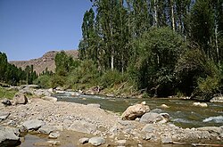
Zola River
| Zola River | |
|---|---|
 | |
| Location | |
| Country | Iran |
| Province | West Azarbaijan province |
| Physical characteristics | |
| Mouth | |
• location | Lake Urmia, Iran |
The Zola River, also known as the Zola Chai is a river in Iran, flowing into Lake Urmia. It runs north of Urmia and west of Salmas city in West Azerbaijan province. Rising in the mountains along the border with Turkey, the Zola flows southwest along the Salmas Plain. The river has a catchment area of 846 km².[1]
Zola Reservoir
[edit]
The river has also been dammed[2] for irrigation. The dam has a height of 83m and a width of 287m and is constructed of an Earth-rock dam with central clay core. The dam holds 85 million m³ of water.[3]
Ecology
[edit]The Zola river is an important component of the ecosystem of the Lake Urmia Basin.[4] Lake Urmia is drying out and has taken on a red color due to phytoplankton in recent years.[5] The health of this river is a key indicator of the health of the whole basin and is therefore the subject of much study.[6]
References
[edit]- ^ Jamshid Yarahmadi, The integration of Satellite Images, GIS and CROPWAT model to investigateion of water balance in irrigated areas:A case stude of Salmas and Tassoj Plains Iran. 2003.
- ^ wetland hydrology and modelling at water basin level - Data User ....
- ^ Conducting of Zola Dam's Construction Archived February 7, 2015, at the Wayback Machine.
- ^ Mohammad Amir Rahmani and Mahdi Zarghami, Studying Climate Change Condition by Wavelet-Ann and System Dynamics Approaches; Zola Reservoir, Iran.
- ^ On the red coloration of Lake Urmia.
- ^ Lake Uromiyeh Baseline Studies - UNDP in Iran.

