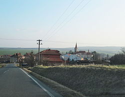
Zlobice
Appearance
Zlobice | |
|---|---|
 General view | |
| Coordinates: 49°18′7″N 17°18′45″E / 49.30194°N 17.31250°E | |
| Country | |
| Region | Zlín |
| District | Kroměříž |
| First mentioned | 1078 |
| Area | |
• Total | 6.64 km2 (2.56 sq mi) |
| Elevation | 229 m (751 ft) |
| Population (2024-01-01)[1] | |
• Total | 591 |
| • Density | 89/km2 (230/sq mi) |
| Time zone | UTC+1 (CET) |
| • Summer (DST) | UTC+2 (CEST) |
| Postal code | 768 31 |
| Website | www |
Zlobice is a municipality and village in Kroměříž District in the Zlín Region of the Czech Republic. It has about 600 inhabitants.
Administrative parts
[edit]The village of Bojanovice is an administrative part of Zlobice.
Geography
[edit]Zlobice is located about 5 kilometres (3 mi) west of Kroměříž, 26 km (16 mi) northwest of Zlín and 50 km (31 mi) east of Brno. It lies in the Litenčice Hills. The highest point is at 390 m (1,280 ft) above sea level. The brook Věžecký potok flows through the municipality.
History
[edit]The first written mention of Zlobice is from 1078.[2]
Demographics
[edit]
|
|
| ||||||||||||||||||||||||||||||||||||||||||||||||||||||
| Source: Censuses[3][4] | ||||||||||||||||||||||||||||||||||||||||||||||||||||||||
Transport
[edit]The D1 motorway from Brno to Ostrava passes north of Zlobice just beyond the municipal border.
Sights
[edit]The main landmark of Zlobice is the Church of Saints Cyril and Methodius. It was built in 1897–1898.[5]
References
[edit]- ^ "Population of Municipalities – 1 January 2024". Czech Statistical Office. 2024-05-17.
- ^ "Historie" (in Czech). Obec Zlobice. Retrieved 2023-09-18.
- ^ "Historický lexikon obcí České republiky 1869–2011" (in Czech). Czech Statistical Office. 2015-12-21.
- ^ "Population Census 2021: Population by sex". Public Database. Czech Statistical Office. 2021-03-27.
- ^ "Kostel sv. Cyrila a Metoděje" (in Czech). National Heritage Institute. Retrieved 2023-09-18.
External links
[edit]Wikimedia Commons has media related to Zlobice.


