Zinkiv Raion
Appearance
Zinkiv Raion
Зіньківський район | |
|---|---|
 | |
| Coordinates: 50°12′30″N 34°21′55″E / 50.20833°N 34.36528°E | |
| Country | |
| Region | Poltava Oblast |
| Established | 7 March 1923 |
| Disestablished | 18 July 2020 |
| Admin. center | Zinkiv |
| Subdivisions | List
|
| Government | |
| • Governor | Oleksandr Tereshenko |
| Area | |
| • Total | 1,360 km2 (530 sq mi) |
| Population (2020) | |
| • Total | 32,763 |
| • Density | 24/km2 (62/sq mi) |
| Time zone | UTC+02:00 (EET) |
| • Summer (DST) | UTC+03:00 (EEST) |
| Postal index | Поштові індекси: |
| Area code | +380-5353 |
| Website | Official homepage |
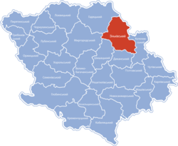
Zinkiv Raion (Ukrainian: Зіньківський район) was a raion (district) in Poltava Oblast of central Ukraine. The raion's administrative center was the city of Zinkiv. The raion was abolished and its territory was merged into Poltava Raion[1] on 18 July 2020 as part of the administrative reform of Ukraine, which reduced the number of raions of Poltava Oblast to four.[2][3] The last estimate of the raion population was 32,763 (2020 est.)[4]
References
[edit]- ^ [1] Нові райони: карти + склад
- ^ "Про утворення та ліквідацію районів. Постанова Верховної Ради України № 807-ІХ". Голос України (in Ukrainian). 2020-07-18. Retrieved 2020-10-03.
- ^ "Нові райони: карти + склад" (in Ukrainian). Міністерство розвитку громад та територій України.
- ^ Чисельність наявного населення України на 1 січня 2020 року / Population of Ukraine Number of Existing as of January 1, 2020 (PDF) (in Ukrainian and English). Kyiv: State Statistics Service of Ukraine. Archived (PDF) from the original on 28 September 2023.


