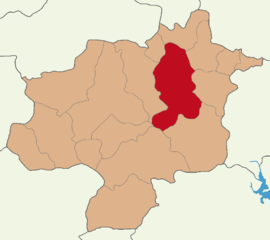
Zara District
Appearance
(Redirected from Zara (Turkish district))
Zara District | |
|---|---|
 Map showing Zara District in Sivas Province | |
| Coordinates: 39°54′N 37°45′E / 39.900°N 37.750°E | |
| Country | Turkey |
| Province | Sivas |
| Seat | Zara |
| Government | |
| • Kaymakam | Meriç Dinçer |
Area | 2,616 km2 (1,010 sq mi) |
| Population (2023) | 23,873 |
| • Density | 9.1/km2 (24/sq mi) |
| Time zone | UTC+3 (TRT) |
| Website | www |
Zara District is a district of the Sivas Province of Turkey. Its seat is the town of Zara.[1] Its area is 2,616 km2,[2] and its population is 23,873 (2022).[3]
Demographics
[edit]Zara District has a Sunni majority and a Kurdish Alevi minority. Lom families are moreover found in the district.[4]
Composition
[edit]There is one municipality in Zara District:[5]
There are 135 villages in Zara District:[6]
- Adamfakı
- Ağlıkçay
- Ahmethacı
- Akdede
- Akdeğirmen
- Akören
- Akyazı
- Alıçbel
- Alıçlıseki
- Alişanağıllı
- Alişir
- Armutçayırı
- Aşağıçamöğü
- Aşağıçamurcu
- Aşağıkovacık
- Aşağımescit
- Atalan
- Atgeçmez
- Atkıran
- Avşar
- Bağlama
- Baharşeyh
- Ballıklar
- Becekli
- Bedirören
- Bektaşköy
- Belentarla
- Beypınarı
- Bozkır
- Bulucan
- Burhaniye
- Büyükgüney
- Büyükkaya
- Büyükköy
- Çandır
- Canova
- Çatören
- Çaylı
- Çaylıca
- Çaypınar
- Cemal
- Çevirmehan
- Çorak
- Çulhaali
- Danışık
- Derbent
- Deredam
- Dereköy
- Dilekpınarı
- Dipsizgöl
- Düzceli
- Ekinli
- Emirhan
- Esenler
- Evrencik
- Eymir
- Girit
- Göhertaş
- Göktepe
- Gölbaşı
- Güllüali
- Gümüşçevre
- İğdeli
- İğdir
- İkideğirmen
- Ilıca
- Kabaktepeler
- Kadriye
- Kanlıçayır
- Kaplan
- Karacahisar
- Karaçayır
- Karahasan
- Karaman
- Kardere
- Karslılar
- Kavasbaşı
- Kayabaşı
- Kayadibi
- Kayılıkaya
- Keçeyurdu
- Kelhasan
- Kevenli
- Kısık
- Kızık
- Kızılkale
- Korkut
- Körpınar
- Kümbet
- Kumoğlu
- Kurucaabat
- Kuruköprü
- Kürünlü
- Kuşçu
- Mahmutağaçiftliği
- Müslümabat
- Nasırköy
- Osmaniye
- Pazarbeleni
- Pazarcık
- Şafaklı
- Sancakkale
- Sarıyusuf
- Sedille
- Selimiye
- Şenyayla
- Şerefiye
- Seten
- Söğütlü
- Söğütlüağıl
- Söğütözü
- Sorkun
- Sucak
- Taşgöze
- Tepeköy
- Tödürge
- Topaktaş
- Tuzlagözü
- Üngür
- Ütük
- Ütükyurdu
- Yapak
- Yarağıl
- Yarımkaya
- Yayıközü
- Yeşildere
- Yeşilköy
- Yeşimli
- Yıkılgan
- Yoğunpelit
- Yolören
- Yukarıçamözü
- Yukarıçamurcu
- Yukarımescit
- Zoğallı
References
[edit]- ^ "Türkiye Mülki İdare Bölümleri Envanteri". T.C. İçişleri Bakanlığı (in Turkish). Retrieved 25 June 2024.
- ^ "İl ve İlçe Yüz ölçümleri". General Directorate of Mapping. Retrieved 22 May 2023.
- ^ "Address Based Population Registration System Results". Türkiye İstatistik Kurumu (in Turkish). Retrieved 25 June 2024.
- ^ Gökbel (2004). İnanç Tarihi Açısından Sivas (in Turkish). p. 276.
- ^ İlçe Belediyesi, Turkey Civil Administration Departments Inventory. Retrieved 22 May 2023.
- ^ Köy, Turkey Civil Administration Departments Inventory. Retrieved 22 May 2023.


