Yerraguntla Junction railway station
Appearance
This article may rely excessively on sources too closely associated with the subject, potentially preventing the article from being verifiable and neutral. (January 2019) |
Yerraguntla Junction | |||||
|---|---|---|---|---|---|
| Express train and Passenger train station | |||||
 Yerraguntla Junction main entrance | |||||
| General information | |||||
| Location | Yerraguntla, YSR Kadapa district, Andhra Pradesh India | ||||
| Coordinates | 14°38′22″N 78°32′06″E / 14.6394°N 78.5349°E | ||||
| Elevation | 152 metres (499 ft) | ||||
| Owned by | Indian Railways | ||||
| Operated by | Guntakal | ||||
| Line(s) | Guntakal–Chennai Egmore section of Mumbai–Chennai line & Nandyal–Yerraguntla section | ||||
| Platforms | 2 | ||||
| Tracks | 5 | ||||
| Construction | |||||
| Structure type | On-ground | ||||
| Parking | available | ||||
| Accessible | |||||
| Other information | |||||
| Status | Functional | ||||
| Station code | YA | ||||
| Fare zone | South Central Railway zone | ||||
| History | |||||
| Opened | 1866 | ||||
| Electrified | Yes | ||||
| |||||
Yerraguntla Junction railway station (station code:YA[1]), is the primary railway station serving Yerraguntla town in the Indian state of Andhra Pradesh. The station comes under the jurisdiction of Guntakal railway division of South Central Railway zone. A new railway line connecting Nandyal of Kurnool district commissioned recently[2]
Station category
[edit]It is one of the 'D' category railway station of Guntakal railway division.
Gallery
[edit]-
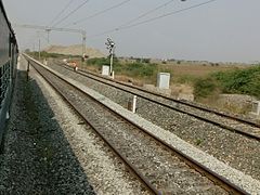
Track bifurcation towards Nandyal Junction
-
Mumbai–Chennai Express near Yerraguntla Junction
References
[edit]- ^ "Distances in kilometers between stations on the Renigunta Jn. – Yerraguntla section" (PDF). Indian Railways. 12 September 2009. p. 90. Retrieved 1 May 2019.
- ^ "Nandyal-Yerranguntla rail line commissioned". The Hindu. 23 August 2016.
External links
[edit]Wikimedia Commons has media related to Yerraguntla Junction railway station.
- Yerraguntla Junction railway station at the India Rail Info


