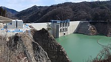
Yamba Dam
You can help expand this article with text translated from the corresponding article in Japanese. (December 2008) Click [show] for important translation instructions.
|
| 八ッ場ダム Yamba Dam | |
|---|---|
 | |
| Location | Gunma Prefecture, Japan |
| Coordinates | 36°33′25″N 138°42′51″E / 36.55694°N 138.71417°E |
| Construction began | 1967 |
| Opening date | 2019 |
| Construction cost | 532 Billion Yen |
| Dam and spillways | |
| Type of dam | Gravity |
| Impounds | Agatsuma River |
| Height | 131 m (430 ft) |
| Length | 336 m (1,102 ft) |
| Reservoir | |
| Creates | Lake Yamba-Agatsuma |
| Total capacity | 107,500,000 m3 (3.80×10⁹ cu ft) |
| Catchment area | 707.9 km2 (273.3 sq mi) |
| Surface area | 304 hectares |
Yamba Dam (八ッ場ダム, Yamba damu) is a dam in Naganohara, Agatsuma District, Gunma Prefecture, Japan. Construction began in 1967, with effective completion in October 2019 and the official opening on 1 April 2020.
Planning for the dam began in 1952, and it was planned to be completed by 2015. The dam's construction had seen sustained local opposition and a ballooning budget, and a change of National government in 2009 resulted in the project being halted, being about 70% completed at the time. Another change of government in 2012 resulted in the project being revived and subsequently completed.
Construction required the relocation of part of the Agatsuma Line, several roads and affected residents.
References
[edit]This article incorporates material from the corresponding article in the Japanese Wikipedia.
