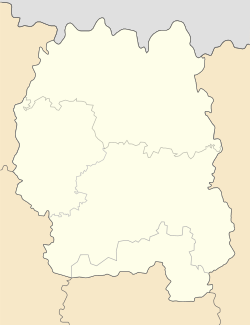
Yablunets
Appearance
Yablunets
Яблунець | |
|---|---|
Location in Zhytomyr Oblast | |
| Coordinates: 50°48′26″N 28°3′43″E / 50.80722°N 28.06194°E | |
| Country | |
| Oblast | |
| Raion | Zviahel Raion |
| Founded | 1910 |
| Urban-type settlement status | 1977 |
| Government | |
| • Mayor | Oleksandr Zinchenko |
| Area | |
• Total | 1.43 km2 (0.55 sq mi) |
| Elevation | 209 m (686 ft) |
| Population (2022) | |
• Total | 1,078 |
| • Density | 750/km2 (2,000/sq mi) |
| Postal code | 11250 |
| Area code | +380 4149 |
Yablunets (Ukrainian: Яблунець) is an urban-type settlement in Zviahel Raion, Zhytomyr Oblast, Ukraine. Population: 1,078 (2022 estimate)[1]
History
[edit]It was a village in Zhitomirsky Uyezd of the Volhynian Governorate of the Russian Empire.
In January 1989 the population was 1497 people.[2]
References
[edit]- ^ Чисельність наявного населення України на 1 січня 2022 [Number of Present Population of Ukraine, as of January 1, 2022] (PDF) (in Ukrainian and English). Kyiv: State Statistics Service of Ukraine. Archived (PDF) from the original on 4 July 2022.
- ^ Всесоюзная перепись населения 1989 г. Численность городского населения союзных республик, их территориальных единиц, городских поселений и городских районов по полу


