Wuchiapingian
| Wuchiapingian | |||||||||||||
|---|---|---|---|---|---|---|---|---|---|---|---|---|---|
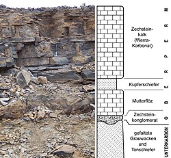
 Wuchiapingian aged stratigraphic succession including the Kupferschiefer, Kamsdorf mine near Saalfeld, Thuringia, Germany | |||||||||||||
| Chronology | |||||||||||||
| |||||||||||||
| Etymology | |||||||||||||
| Name formality | Formal | ||||||||||||
| Usage information | |||||||||||||
| Celestial body | Earth | ||||||||||||
| Regional usage | Global (ICS) | ||||||||||||
| Time scale(s) used | ICS Time Scale | ||||||||||||
| Definition | |||||||||||||
| Chronological unit | Age | ||||||||||||
| Stratigraphic unit | Stage | ||||||||||||
| Time span formality | Formal | ||||||||||||
| Lower boundary definition | FAD of the Conodont Clarkina postbitteri postbitteri | ||||||||||||
| Lower boundary GSSP | Penglaitan Section, Laibin, Guangxi, China 23°41′43″N 109°19′16″E / 23.6953°N 109.3211°E | ||||||||||||
| Lower GSSP ratified | 2004[2] | ||||||||||||
| Upper boundary definition | Meishan, Zhejiang, China | ||||||||||||
| Upper boundary GSSP | FAD of the Conodont Clarkina wangi 31°04′55″N 119°42′23″E / 31.0819°N 119.7064°E | ||||||||||||
| Upper GSSP ratified | 2005[3] | ||||||||||||
In the geologic timescale, the Wuchiapingian or Wujiapingian (from Chinese: 吴家坪; pinyin: Wújiāpíng; lit. 'Wu Family Flatland' in the Liangshan area of Hanzhong, Shaanxi Province[4] 33°03′59″N 107°01′24″E / 33.0664°N 107.0232°E) is an age or stage of the Permian. It is also the lower or earlier of two subdivisions of the Lopingian Epoch or Series. The Wuchiapingian spans the time between 259.51 and 254.14 million years ago (Ma). It was preceded by the Capitanian and followed by the Changhsingian.[5]
Regional stages with which the Wuchiapingian is coeval or overlaps include the Djulfian or Dzhulfian, Longtanian, Rustlerian, Saladoan, and Castilian.[6]
Stratigraphic definitions
[edit]The Wuchiapingian was first used in 1962, when the Lopingian Series of southwestern China was divided in the Changhsingian and Wuchiapingian Formations. In 1973 the Wuchiapingian was first used as a chronostratigraphic unit (i.e. a stage, as opposed to a formation, which is a lithostratigraphic unit).[7]
The base of the Wuchiapingian Stage is defined as the place in the stratigraphic record where the conodont species Clarkina postbitteri postbitteri first appears. A global reference profile for this boundary (a GSSP) is located near Laibin in the Chinese province of Guangxi.[2]
The top of the Wuchiapingian (the base of the Changhsingian) is at the first appearance of conodont species Clarkina wangi.
The Wuchiapingian contains two ammonoid biozones: that of the genus Araxoceras and that of the genera Roadoceras and Doulingoceras.
Wuchiapingian life
[edit]An extinction pulse occurred during the Wuchiapingian; faunas were recovering when another larger extinction pulse, the Permian–Triassic extinction event devastated life.[8]
A relatively diverse fish fauna is known from the coeval Kupferschiefer (Werra Formation, Germany), Marl Slate Formation (England) and Ravnefjeld Formation (Greenland), including, among others, the following genera: Acentrophorus, Acropholis, Boreolepis, Coelacanthus, Dorypterus, Janassa, Menaspis, Palaeoniscum, Platysomus, Pygopterus and Wodnika.[9][10] The Hambast Formation of Iran yielded chondrichthyan faunas of Wuchiapingian to Changhsingian age. The Wuchiapingian layers produced teeth of the eugeneodontid Bobbodus.[11]
Notable formations
[edit]- Hambast Formation (Iran)
- Marl Slate Formation (England)
- Naobaogou Formation (Inner Mongolia, China)
- Ravnefjeld Formation (Greenland)
- Sunjiagou Formation (Shanxi, China)
- Tropidostoma Assemblage Zone* (South Africa)
- Werra Formation (Kupferschiefer, Germany)
References
[edit]- ^ "International Chronostratigraphic Chart" (PDF). International Commission on Stratigraphy. September 2023. Retrieved 10 November 2024.
- ^ a b Jin, Yugan; Shen, Shuzhong; Henderson, Charles; Wang, Xiangdong; Wang, Wei; Wang, Yue; Cao, Changqun; Shang, Qinghua (December 2006). "The Global Stratotype Section and Point (GSSP) for the boundary between the Capitanian and Wuchiapingian Stage (Permian)" (PDF). Episodes. 29 (4): 253–262. doi:10.18814/epiiugs/2006/v29i4/003. Retrieved 13 December 2020.
- ^ Jin, Yugan; Wang, Yue; Henderson, Charles; Wardlaw, Bruce; Shen, Shuzhong; Cao, Changqun (September 2006). "The Global Boundary Stratotype Section and Point (GSSP) for the base of Changhsingian Stage (Upper Permian)". Episodes. 29 (3): 175–182. doi:10.18814/epiiugs/2006/v29i3/003.
- ^ "陕西汉中梁山吴家坪灰岩的再研究 (Restudies on the Wujiaping Limestone Liangshan of Hanzhong, Shaanxi)". Retrieved 29 November 2012.
- ^ Gradstein, F.M.; Ogg, J.G.; Smith, A.G. (2004). A Geologic Time Scale 2004. Cambridge University Press.
- ^ "Wuchiapingian". GeoWhen Database, International Commission on Stratigraphy (ICS). Retrieved 4 March 2010.
- ^ Kanmera, Kametoshi; Nakazawa, Keiji (1973). "Permian-Triassic relationships and faunal changes in the eastern Tethys". In Logan, A.; Hills, L. V. (eds.). The Permian and Triassic Systems and their mutual boundary. Canadian Society of Petroleum Geologists, Memoir 2. pp. 100–129.
- ^ Sahney, S. & Benton, M.J. (2008). "Recovery from the most profound mass extinction of all time". Proceedings of the Royal Society B: Biological Sciences. 275 (1636): 759–65. doi:10.1098/rspb.2007.1370. PMC 2596898. PMID 18198148.
- ^ Schaumberg, Günther (1977). "Die Richelsdorfer Kupferschiefer und seine Fossilien, III". Aufschluss (in German). 28: 297–352.
- ^ Romano, Carlo; Koot, Martha B.; Kogan, Ilja; Brayard, Arnaud; Minikh, Alla V.; Brinkmann, Winand; Bucher, Hugo; Kriwet, Jürgen (February 2016). "Permian-Triassic Osteichthyes (bony fishes): diversity dynamics and body size evolution". Biological Reviews. 91 (1): 106–147. doi:10.1111/brv.12161. PMID 25431138. S2CID 5332637.
- ^ Hampe, Oliver; Hairapetian, Vachik; Dorka, Markus; Witzmann, Florian; Akbari, Amir M.; Korn, Dieter (2013). "A first Late Permian fish fauna from Baghuk Mountain (Neo-Tethyan shelf, central Iran)". Bulletin of Geosciences. 88 (1): 1–20. doi:10.3140/bull.geosci.1357. ISSN 1214-1119.
External links
[edit]- GeoWhen Database - Wuchiapingian
- Upper Paleozoic stratigraphic chart at the website of the subcommission for stratigraphic information of the ICS
