Wootton, Kent
| Wootton | |
|---|---|
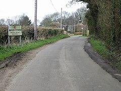
 Entering Wootton from the south | |
Location within Kent | |
| Civil parish | |
| District | |
| Shire county | |
| Region | |
| Country | England |
| Sovereign state | United Kingdom |
| Post town | Canterbury |
| Postcode district | CT4 |
| Police | Kent |
| Fire | Kent |
| Ambulance | South East Coast |
Wootton is a village and former civil parish, now in the parish of Denton with Wootton, in the Dover district of Kent, England. In 1961 the parish had a population of 164.[1]
The village is 7 miles (11 km) northwest from the channel port of Dover, and 30 miles (48 km) east-southeast from the county town of Maidstone. The major A2 London to Dover road is 1 mile (1.6 km) to the northeast. Denton, the other parish village, is 1 mile to the northwest.
History
[edit]
Wootton was the birthplace of the mathematician and surveyor Leonard Digges, who some claim invented a functioning telescope some time between 1540 and 1559.
It once had a Baptist chapel, linked to the Eythorne Baptist Church group. The worldwide known Lydden Hill Race Circuit, the so-called "Home of Rallycross", is located near Wootton village.
On 1 April 1963 the parish was abolished and merged with Denton to form "Denton with Wootton".[2]
References
[edit]- ^ "Population statistics Wootton AP/CP through time". A Vision of Britain through Time. Retrieved 14 June 2023.
- ^ "Relationships and changes Wootton AP/CP through time". A Vision of Britain through Time. Retrieved 14 June 2023.
External links
[edit]![]() Media related to Wootton, Kent at Wikimedia Commons
Media related to Wootton, Kent at Wikimedia Commons


