William H. Putnam Memorial Bridge
Putnam Bridge | |
|---|---|
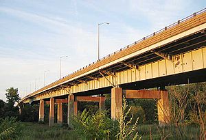
 Western end of the William H. Putnam Memorial Bridge, before rehabilitation. | |
| Coordinates | 41°42′51″N 72°38′27″W / 41.71417°N 72.64083°W |
| Carries | 4 lanes of |
| Crosses | Connecticut River |
| Locale | Wethersfield, Connecticut and Glastonbury, Connecticut |
| Official name | William H. Putnam Memorial Bridge |
| Characteristics | |
| Design | Steel girder bridge |
| Clearance below | 80 ft (24.3 m) |
| Statistics | |
| Daily traffic | 50,800 |
| Location | |
 | |
The Putnam Bridge is a bridge in the state of Connecticut carrying the Route 3 freeway over the Connecticut River, connecting Interstate 91 in Wethersfield and Route 2 in Glastonbury. It is the southernmost crossing of the Connecticut River in the Hartford Area and carries an average of 50,800 vehicles per day.[1]
The bridge was built in the late 1950s as part of the Route 3 freeway between Interstate 91 and Route 2. It originally terminated at Main Street in Glastonbury, rather than at Route 2. It was expected to be expanded to a double-decker in the early 1970s as part of the planned Interstate 491, a southeastern bypass around Hartford from Wethersfield to East Hartford. However, the project was cancelled in 1973. In the late 1980s, the freeway portion of Route 3 was extended to terminate at Route 2.
In 2013, the bridge underwent a $15 million rehabilitation project, which repaved the roadbed, repainted the girders, added new lighting fixtures and a new pedestrian walkway.
See also
[edit]References
[edit]External links
[edit]
- Glastonbury, Connecticut
- Wethersfield, Connecticut
- Bridges over the Connecticut River
- Bridges in Hartford County, Connecticut
- Road bridges in Connecticut
- Steel bridges in the United States
- Girder bridges in the United States
- 1950s establishments in Connecticut
- Bridges completed in the 20th century
- Northeastern United States bridge (structure) stubs
- Connecticut building and structure stubs
- Connecticut transportation stubs
