Wilby, Victoria
Appearance
| Wilby Victoria | |||||||||||||||
|---|---|---|---|---|---|---|---|---|---|---|---|---|---|---|---|
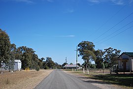
 Wilby looking towards the old Wilby pub | |||||||||||||||
| Coordinates | 36°09′28″S 146°00′57″E / 36.15778°S 146.01583°E | ||||||||||||||
| Population | 166 (2016 census)[1] | ||||||||||||||
| Postcode(s) | 3728 | ||||||||||||||
| LGA(s) | Shire of Moira | ||||||||||||||
| State electorate(s) | Ovens Valley | ||||||||||||||
| Federal division(s) | Nicholls | ||||||||||||||
| |||||||||||||||
Wilby is a town located in the Shire of Moira Local Government Area, Victoria. The post office opened on 10 July 1883 and was closed on 30 June 1978.[2]
At the 2016 census, Wilby had a population of 166.[1]
References
[edit]- ^ a b "2016 Census QuickStats Wilby". Australian Bureau of Statistics. Retrieved 2 November 2018.
- ^ Premier Postal History, Post Office List, retrieved 11 April 2008
External links
[edit]![]() Media related to Wilby, Victoria at Wikimedia Commons
Media related to Wilby, Victoria at Wikimedia Commons

