Wikipedia:WikiProject U.S. Roads/Newsletter/Issues/Volume03/Issue02

|
| Volume 3, Issue 2 • Summer 2010 • About the Newsletter |
IntroductionIn this issue
Welcome to the second quarterly newsletter for the US Roads Project. There's been a lot going on lately around the project, as you'll read below. Summer tends to be one of our slower seasons in terms of editing around here. That's probably because the weather's nice, and some of us get out on road trips and other summer activities. Project members have been working on various projects related to the templates we use in the project. Fredddie recounts this issue the overhauls that have been made to {{Infobox road}}. Similar updates have been made to its siblings, {{Infobox road small}}, {{Infobox road junction}} and {{Infobox state highway system}}. The net effect is to visually "re-brand" the look of not just USRD, but the larger Highways Project. The infobox project has led to a consolidation of the various templates in use for other countries' highway articles. Before the project, several countries used {{Infobox road}} in addition to the US, notably Canada, South Africa and Japan. The template has been rolled out most of Europe and several Asian nations. There have been 35 infoboxes consolidated into the template and tagged for deletion. To all of our project editors out there, keep up the good work to expand the stubs and improve the project, one article at a time. | ||||||||||||||||||||||||||||||||||||||||||||||||||||||||||||||||||||||||||||||||||||||||||||||||||||||||||||||||||||||||||||||||||||||||||||||||||||||||||||||||||
Infobox road upgrade
Over the last couple months, a number of us have set aside our quest to reduce the number of stubs for a different task: updating {{Infobox road}}. {{Infobox road}} was created by Hillrhpc (talk · contribs) back in 2005 when this project was just getting started. In 2006, SPUI (talk · contribs) and NE2 (talk · contribs), among others, expanded the template, created the large backend of the template that's still in use today. Over the next couple years, parameters were added to allow {{Infobox road}} to be used worldwide and not just in the United States. Earlier this year, Imzadi1979 (talk · contribs) proposed adding some color to the template by creating a mockup. Fredddie (talk · contribs) responded with another mockup using the meta-template {{Infobox}}, which facilitates the creation of infoboxes. The result was positive; the mockup Fredddie made was preferred and the testing phase began. A number of us put the update through the wringer to make sure any issues that arose would be kept at a minimum. The new look of {{Infobox road}} went live on June 11. After it went live, TwinsMetsFan (talk · contribs) began an overhaul of the backend of the template. Parameters were streamlined and new subtemplates were created. Rschen7754 (talk · contribs) created a page listing how other countries used highway infoboxes; the results were surprising. As of July 2010, we're going through and adding parameters to allow {{Infobox road}} to be used around the world! Instead of calling a subtemplate for each type of highway in each state, (that's over 150 subtemplates in just the US alone!), it calls 6 subtemplates total per country. Details on how it all works can be seen at Template:Infobox road/doc. What started as a routebox for this project has evolved into a robust template with worldwide usage. Great job to everyone who's helped along the way! | ||||||||||||||||||||||||||||||||||||||||||||||||||||||||||||||||||||||||||||||||||||||||||||||||||||||||||||||||||||||||||||||||||||||||||||||||||||||||||||||||||
Editing needed near bottom of leaderboard
At USRD, there are a few states that have several exceptional articles, such as Michigan, New Jersey, and New York. Yet there are many states that have only a few decent articles, with the remainder being mostly stubs. One of these states I came across was Mississippi, which at the time was at the bottom of the leaderboard among the 50 states and had no articles above start-class. In addition, only a couple articles had infoboxes and most articles had a bulleted list of communities and junctions in place of prose. Upon finding resources from the Mississippi Department of Transportation (MDOT), I managed to get three Mississippi articles to B-class and one, Mississippi Highway 172, to Good Article status. This improvement shows how we need to make inroads to bring articles in the bottom states up to par. With resources such as old maps available from MDOT, I encourage editors to work on improving Mississippi road articles. However, there are several other states near the bottom of the leaderboard, such as Arkansas, Georgia, and Louisiana; as well as several territories including American Samoa, Puerto Rico, and the U.S. Virgin Islands. As editors, we should strive to work on improving articles in these states to at least B-class quality and introduce good practices that are currently in place in the several quality articles that exist throughout USRD. | ||||||||||||||||||||||||||||||||||||||||||||||||||||||||||||||||||||||||||||||||||||||||||||||||||||||||||||||||||||||||||||||||||||||||||||||||||||||||||||||||||
Junction list updates
Recent discussions at WT:RJL have resulted in a change to how junction lists internationally need to be formatted. These lists now need to have a table footer row added that gives conversion information between miles and kilometers and vice versa. This change allows foreign editors to make the conversions of distance data in the chart if desired without requiring any additional changes. The alternate solution would have been to add another column to the table with the converted values. The table footers were chosen as the simplest solution that complies with the guidance at MOS:CONVERSIONS. To accommodate this change, two templates, {{jctbtm}} and {{legendRJL}} were both modified to show the conversion values. Tables created using the different templates should not need to be changed, although the former template might need the | ||||||||||||||||||||||||||||||||||||||||||||||||||||||||||||||||||||||||||||||||||||||||||||||||||||||||||||||||||||||||||||||||||||||||||||||||||||||||||||||||||
| ||||||||||||||||||||||||||||||||||||||||||||||||||||||||||||||||||||||||||||||||||||||||||||||||||||||||||||||||||||||||||||||||||||||||||||||||||||||||||||||||||
Assessment roundup
We've had a big shakeup on the leaderboard since last issue, and the reason why is because of the assessment audits that have been occurring this summer. Our intrepid project members have examined every article in USRD, state by state, and adjusted their assessment ratings as appropriate. Unfortunately, this means that a lot of states have seen their stub counts rise and B-Class articles drop because of application of outdated assessment criteria. Some states had a lot of articles mis-assessed, but others only changed slightly. So how did that affect the states relative to one another? To help us find out, here's the leaderboard for August 17, 2010!
States in parentheses have no project. States listed in italics are task forces. Michigan remains on top as usual, but just about everything else has changed. New Jersey and Utah have both passed New York, which dropped to fourth. Arizona and Iowa have held steady, remaining at fifth and tenth place respectively. Connecticut rose from 8th to 6th, while Delaware dropped from 7th to 9th. Oklahoma and Washington were bumped from the leaderboard entirely, being replaced by Maryland and Colorado. As always, you can always find a full listing at WP:USRD/A/S. Now, here are the stats for the national projects:
Unfortunately, the audits have impacted our progress towards the goal of reduce the number of stubs by 3,000 by December 31. Our goal is 2967. As of August 17, we had 4909 stubs, which means we need to expand, merge, or otherwise get rid of 1,942 stubs over the rest of 2010. Although we have made some progress over the past three months, it is not as much as we could have hoped. We will need an extra boost of effort to clear out the remaining 1,942 stubs—we have just over four months left to do it if we want to achieve the goal! |
Project reportsThe most significant development of the past three months is a massive reduction in the number of stubs under the umbrella of the Roads in Maryland WikiProject. The stub count decreased from over 200 at the beginning of April to about 15 by the middle of June. All specific numbered highway articles in Maryland are now a minimum of Start-class. In addition to my work in expanding the stubs, credit goes to Dough4872 and Onore Baka Sama for their work in adding Route descriptions and Junction lists to those articles in need of them. Part of the stub removal drive was consolidating those routes lacking enough information for their own articles, a task intertwined with the reduction and ultimate retirement of the minor routes list. The original plan hatched in late March was to expand more significant routes into their own articles and to place those minor routes lacking enough information for a suitable stand-alone article into the articles of their "parent." However, by the middle of May, consensus shifted away from placing related routes in their parent articles. The related routes scheme was less arbitrary than placing such highways in a minor routes list, but it was still arbitrary. A more objective approach was suggested to group all routes shorter than one mile together. That approach was adopted in the form of the List of state highways in Maryland shorter than one mile. After that infrastructure was settled upon, the next step was to create articles for those routes in the minor routes list that were not shorter than one mile. Once all of those routes were removed, the remaining routes could then be transferred to the new list of highways shorter than one mile with minimal required revision. As of the middle of June, the final route longer than one mile was removed from the minor routes list. The remaining routes in the minor routes list are in the process of being added to the List of state highways in Maryland shorter than one mile, a process that should be completed by the end of July. At that time, all references and links to the minor routes list will be changed to point to the new list and the minor routes list will be marked for deletion. Since the Spring 2010 newsletter, four articles have been awarded Good Article status: U.S. Route 220 in Maryland, U.S. Route 113, U.S. Route 219 in Maryland, and Interstate 895 (Maryland). In addition to retiring the minor routes list and continuing to improve the overall quality of Maryland highway articles, one goal for the near future is to comprehensively update the WikiProject front page to eliminate old information and make sure present guidelines are well communicated. This is especially important because editors come and go, so both veterans and novices need the most up-to-date information to properly continue the task of improving Maryland highway articles. — Viridiscalculus | |||||||||||||||||||||||||||||||||||||||||||||||||||||||||||||||||||||||||||||||||||||||||||||||||||||||||||||||||||||||||||||||||||||||||||||||||||||||||||||||||
News in brief
| ||||||||||||||||||||||||||||||||||||||||||||||||||||||||||||||||||||||||||||||||||||||||||||||||||||||||||||||||||||||||||||||||||||||||||||||||||||||||||||||||||
Selected articles
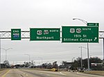 Interstate 359 (I-359) is a part of the Interstate Highway System in the US state of Alabama. It is a spur route that runs for 2.76 miles (4.44 km) entirely within the city limits of Tuscaloosa. Its termini are just south of I-20/I-59 interchange on the south side of town and U.S. Highway 43 (US 43) in downtown Tuscaloosa. The entire length is concurrent with U.S. Highway 11 (US 11) and Alabama State Route 69 (SR 69), with both continuing as at-grade thoroughfares north and south of the shorter Interstate. In the early 1960s, local planners and elected officials stated the need for direct access to Interstate 59 from the city of Tuscaloosa. As annexation had not yet brought the city limits to the I-59 corridor, Interstate 359 was originally to be the only access provided to I-59 directly from Tuscaloosa. The route as originally envisioned, was to have has no exits for the duration of its route between its southern terminus at I-59 and its northern terminus at 15th Street in downtown Tuscaloosa. Actual planning for I-359 commenced in 1961. Planning for the corridor continued throughout the 1970s, only to stall briefly due to complications with the required environmental impact assessment associated with the project. Construction would commence in 1980 on the first phase of the freeway, and the first segment of I-359 opened to traffic in October 1982 between I-20/59 and Exit 1. The freeway was officially dedicated and opened for traffic on September 13, 1983. |
Selected pictures
 Looking west over Interstate 235 in Des Moines, Iowa, from the Edna M. Griffin Memorial Bridge. | |||||||||||||||||||||||||||||||||||||||||||||||||||||||||||||||||||||||||||||||||||||||||||||||||||||||||||||||||||||||||||||||||||||||||||||||||||||||||||||||||
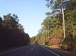 U.S. Route 113 (US 113) is a spur of U.S. Route 13 in the U.S. states of Maryland and Delaware. The highway runs 74.75 mi (120.30 km) from US 13 in Pocomoke City, Maryland north to Delaware Route 1 (DE 1) in Milford, Delaware. US 113 is the primary highway within Worcester County, Maryland, connecting the county's three population centers of Pocomoke City, Snow Hill, and Berlin. The highway also provides access to Ocean City via its connections with US 50 and Maryland Route 90. US 113 is one of three major north–south highways in Sussex County, Delaware, connecting Selbyville, Georgetown, and Milford. The highway links those towns with Dover and Wilmington in conjunction with DE 1. US 113 is a four-lane divided highway for its whole length except for between Snow Hill and Berlin; that two-lane section is currently being rebuilt as a dual highway. US 113 is part of the National Highway System along its entire length. US 113 follows the corridor of a post road established in the 18th century connecting the aforementioned towns on the Delmarva Peninsula. The highway was improved as an all-weather road in the 1910s; in Maryland, the highway was one of the original state roads established in 1909, while in Delaware the highway was the Selbyville–Dover portion of the DuPont Highway. The highway was designated US 113 as part of the original U.S. Highway System in 1926. The highway was widened in both states in the 1930s and 1940s. Expansion to a divided highway began in both states in the late 1950s, with dualization completed in Delaware in the mid 1990s. US 113 has bypassed the centers of Pocomoke City, Snow Hill, and Berlin, while in Delaware the only major realignment was within and to the south of Dover. The bypassed portions of highway in Snow Hill and Dover became bannered routes of US 113. US 113's northern terminus was moved south from Dover to Milford in 2004. |
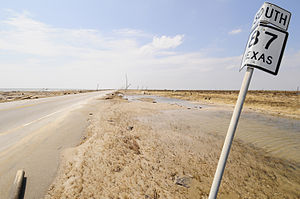 The Gulf of Mexico shoreline looking south along State Highway 87 towards Gilchrist, Texas, where beachfront houses once dotted the landscape. Hurricane Ike left little trace of their existence.
| |||||||||||||||||||||||||||||||||||||||||||||||||||||||||||||||||||||||||||||||||||||||||||||||||||||||||||||||||||||||||||||||||||||||||||||||||||||||||||||||||
 Interstate 235 (I-235) in Iowa is an auxiliary Interstate Highway which runs just north of downtown Des Moines through the heart of the Des Moines metropolitan area. I-235 runs from the junction of Interstate 35 and Interstate 80 in West Des Moines to the separation of the same two interstates in Ankeny. The highway is approximately 14 miles (23 km) long. I-235, which had seen little improvement since its construction in the 1960s, was completely rebuilt and widened in a project that spanned most of the 2000s. Prior to the reconstruction, I-235 had two lanes in each direction with a third lane near downtown; the entire route now has at least three lanes of traffic in each direction, with an additional one or two lanes closer to the heart of the city. The modernized freeway now handles on average between 75,000–125,000 vehicles per day, making it the busiest highway in the state of Iowa. |
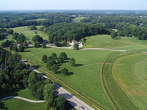 Delaware Route 52 in the Brandywine Valley north of Wilmington
| |||||||||||||||||||||||||||||||||||||||||||||||||||||||||||||||||||||||||||||||||||||||||||||||||||||||||||||||||||||||||||||||||||||||||||||||||||||||||||||||||
From the editorsWe're gonna do this more! Since the newsletter returned in April, it's been decided to keep to a quarterly schedule in the future. If future events warrant, look for special editions delivered to your talk page. The editors of the newsletter would like to hear from you, the reader. What do you like about the current format? What should be changed? Removed? Added? Your comments are needed. Lastly, remember that this is your newsletter and you can be involved in the creation of the next issue released in October. Any and all contributions are welcome. Simply let yourself be known to any of the undersigned, or just start editing! |
Contributors to this issue
| |||||||||||||||||||||||||||||||||||||||||||||||||||||||||||||||||||||||||||||||||||||||||||||||||||||||||||||||||||||||||||||||||||||||||||||||||||||||||||||||||

