Wikipedia:Main Page history/2020 August 31
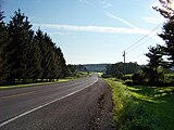
From today's featured articleNew York State Route 175 is a west–east state highway located in Onondaga County, New York, in the United States. The 15.46-mile (24.88 km) route begins at an intersection with U.S. Route 20 east of the village of Skaneateles. It heads towards the northeast as Lee Mulroy Road, traversing farmland. It then passes through the village of Marcellus before ending at a junction with U.S. Route 11 in Syracuse. Designated in the 1930 renumbering of state highways in New York, the highway brought about an increase in population and development along its route. The section of Route 175 from downtown Marcellus to New York State Route 173 in Onondaga was built along the historical Seneca Turnpike, which was established in 1800 and dissolved in 1852. At 157 miles (253 km), the turnpike was the longest in the state at the time and was instrumental in the development of the villages of Skaneateles and Marcellus. (Full article...)
Recently featured:
Did you know ...
|
In the news
On this dayAugust 31: Independence Day in Malaysia (1957)
More anniversaries:
|
From today's featured list
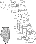
Chicago is divided into 77 community areas for statistical and planning purposes. Census data and other statistics are tied to the areas, which serve as the basis for a variety of urban planning initiatives on both the local and regional levels. The areas' boundaries do not generally change, allowing comparisons of statistics across time. The areas are distinct from but related to the more numerous neighborhoods of Chicago. As of 2017[update], Lake View is the most populous of the areas, with more than 100,000 residents, while Burnside is the least populous, with just over 2,000. The Social Science Research Committee at the University of Chicago defined the community areas in the 1920s based on neighborhoods or groups of related neighborhoods within the city. In this effort it was led by sociologists Robert E. Park and Ernest Burgess, who believed that physical contingencies created areas that would inevitably form a common identity. (Full list...)
Today's featured picture

|
The bank myna (Acridotheres ginginianus) is a passerine bird found in flocks on the plains of northern and central India. Its usual habitat is cultivated farmland, usually in the vicinity of open water, but flocks will often live within cities, in markets and railway stations. Its common name comes from its propensity to nest in large colonies in holes excavated in the banks of rivers, although other sites are sometimes chosen. It feeds on grain, insects and fruits, and sometimes follows grazing animals, picking up disturbed insects or even ticks off the animals' backs. In towns, it makes use of food dropped by humans, even following catering vehicles at airports. This bank myna was photographed in the Indian state of Uttar Pradesh. Photograph credit: Charles J. Sharp
Recently featured:
|
Other areas of Wikipedia
- Community portal – Bulletin board, projects, resources and activities covering a wide range of Wikipedia areas.
- Help desk – Ask questions about using Wikipedia.
- Local embassy – For Wikipedia-related communication in languages other than English.
- Reference desk – Serving as virtual librarians, Wikipedia volunteers tackle your questions on a wide range of subjects.
- Site news – Announcements, updates, articles and press releases on Wikipedia and the Wikimedia Foundation.
- Village pump – For discussions about Wikipedia itself, including areas for technical issues and policies.
Wikipedia's sister projects
Wikipedia is hosted by the Wikimedia Foundation, a non-profit organization that also hosts a range of other projects:
Free media repository
Wiki software development
Wikimedia project coordination
Free textbooks and manuals
Free knowledge base
Free-content news
Collection of quotations
Free-content library
Directory of species
Free learning resources
Free travel guide
Dictionary and thesaurus


