Wikipedia:Graphics Lab/Map workshop/Archive/Nov 2013
Stale
[edit]Resolved
[edit]Asia country maps - South Sudan and Eritrea
[edit]Article(s): Every article these maps are already on.
Request:
- Would someone please draw in the border between Sudan and South Sudan on all these maps, as well as the border between Ethiopia and Eritrea on whichever maps it is missing on.
Graphist opinion(s):
- Please WP:SIGN your posts.
- Please also see this reply: Wikipedia:Graphics_Lab/Map_workshop/Archive/Aug_2013#Africa_Countries_Maps_-_South_Sudan
- Happy to help if you have any more specific requests with specified details, suitable for workshop attention, not covered by the advice there. Thanks. Begoon talk 16:29, 1 November 2013 (UTC)
Mistake on midwest U.S. war of 1812 map
[edit]-
Location map of actions in western Midwest in war of 1812
Article(s): War of 1812 and Battle of the Sink Hole Campbell's Island, Illinois Credit Island Fort Bellefontaine Fort Cap au Gris Fort Johnson Fort Osage Fort Shelby (Wisconsin) Siege of Prairie du Chien Illinois Territory in the War of 1812
Request:
- Wisconsin was part of Illinois Territory in 1812, not Indiana Territory as the map shows. -- Rmhermen (talk) 17:44, 1 November 2013 (UTC)
- Yeah - I'm probably being dense here, but I don't really understand what edit to make. There don't seem to be any "boundaries" on the map, so I guess you'd like a label (or labels) moved - but silly old me doesn't know which one(s) to where? Begoon talk 18:20, 1 November 2013 (UTC)
- The map has a label Indiana Territory north of Illinois Territory - but Indiana is entirely east of the area covered on this map. The northern area is just more Illinois (now Wisconsin). Rmhermen (talk) 18:39, 1 November 2013 (UTC)
- Ok - so, please don't hit me, but what should I move (or change, or relabel) exactly? I'm just a graphics monkey, you see... Do you just want the Indiana label removed? (moved east off the map...), or the Illinois label moved up too (or something else) I'm so sorry I'm so stupid... Begoon talk 18:49, 1 November 2013 (UTC)
- Just removed is fine. Might it be possible to move the Illinois label further up so the river doesn't run through it? Rmhermen (talk) 20:57, 1 November 2013 (UTC)
- Yes, sorry for disappearing, I had to go out. I'll do that shortly for you. Begoon talk 05:34, 2 November 2013 (UTC)
- - Ok -
 Done (clear cache/purge if you don't see it) - sorry for the delay. Begoon talk 06:40, 2 November 2013 (UTC)
- - Ok -
- Yes, sorry for disappearing, I had to go out. I'll do that shortly for you. Begoon talk 05:34, 2 November 2013 (UTC)
- Just removed is fine. Might it be possible to move the Illinois label further up so the river doesn't run through it? Rmhermen (talk) 20:57, 1 November 2013 (UTC)
- Ok - so, please don't hit me, but what should I move (or change, or relabel) exactly? I'm just a graphics monkey, you see... Do you just want the Indiana label removed? (moved east off the map...), or the Illinois label moved up too (or something else) I'm so sorry I'm so stupid... Begoon talk 18:49, 1 November 2013 (UTC)
- The map has a label Indiana Territory north of Illinois Territory - but Indiana is entirely east of the area covered on this map. The northern area is just more Illinois (now Wisconsin). Rmhermen (talk) 18:39, 1 November 2013 (UTC)
- Yeah - I'm probably being dense here, but I don't really understand what edit to make. There don't seem to be any "boundaries" on the map, so I guess you'd like a label (or labels) moved - but silly old me doesn't know which one(s) to where? Begoon talk 18:20, 1 November 2013 (UTC)
Looks good. Thanks. Rmhermen (talk) 20:34, 2 November 2013 (UTC)
Illinois locator map
[edit]-
Locator map of Illinois
-
New Locator map of Illinois
Article(s): Almost one thousand articles currently use this map!
Request:
- Please add a line showing the boundary between two counties. I've just noticed that the boundary between Clinton County and Washington County is missing, making the two appear to be one county. File:Map of Illinois highlighting Clinton County.svg and File:Map of Illinois highlighting Washington County.svg will show you where the border should be placed. Nyttend (talk) 01:09, 8 September 2013 (UTC)
Graphist opinion(s):
- Comment:Looked over the maps to possibly copy the offending line into the outline map, and came upon a possible separate error with the county highlighted maps listed (Clinton, Washington), along with all the other highlighting maps for Illinois. None of the SVGs are rendering at all, only the PNG replacements. I ran a couple through the W3C validator, and they returned errors. Do all the locator maps for Illinois need to be recreated? Can someone verify this for me? If this is the case, I will volunteer to take on the project, along with fixing the initial outline map request. 25or6to4 (talk) 02:09, 8 September 2013 (UTC)
 Done I hope you colonialists can make use of this adapted map. Regards, Wereldburger758 (talk) 14:21, 25 October 2013 (UTC)
- Comment: I just copied File:Illinois - outline map.svg (the "New locator map" above) to File:Illinois - outline map.svg (the first one above), with credit to Commons:User:Citypeek in the upload summary, then nominated File:Illinois - outline map.svg for speedy deletion as a duplicate. The W3C Validator with validator.nu Conformance Checker warns that it only works on version 1.1 of the SVG standard, but it validated this file (which says version="1.0") as valid SVG 1.1. --Closeapple (talk) 02:29, 4 November 2013 (UTC)
- ty for the good work. Wereldburger758 (talk) 14:54, 14 November 2013 (UTC) (also known as Citypeek)
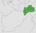
Badakhshan
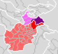
[edit]Article(s): Badakhshan
Request:
- I think this one is quite self-explanatory. Please help. Thank you. -- Gryffindor (talk) 08:26, 7 November 2013 (UTC)
Graphist opinion(s):
- Done. Wereldburger758 (talk) 15:13, 19 November 2013 (UTC)
- Could you change some things please? There are too many colours. Please colour all of Afghanistan the same grey like the other countries and remove the borders of the provinces. Colour the green part of Tajikistan into grey as well. The purple and the red colour should both be a light green. The border dividing them should be in white. Gryffindor (talk) 16:51, 19 November 2013 (UTC)
- Why colour two regions in the same colour (light green)? Must there some text be added to tell them apart? And do you have a specific light green colour in mind (hex-code). If so, paste the hex-code down below. Wereldburger758 (talk) 17:03, 19 November 2013 (UTC)
- Because the map needs to illustrate the one region, even if it is divided today. You can also take the same green as is used right now for Tajikistan. Thank you. Gryffindor (talk) 17:15, 19 November 2013 (UTC)
- And the borders of the regions of Tajikistan? Remove those too? Wereldburger758 (talk) 17:50, 19 November 2013 (UTC)
- I don't think I see any borders. Are you referring to the rivers maybe? The way it looks now is perfectly fine, thank you very much for your help. I think you missed a little squiggle of provincial border at the middle lower part of Afghanistan. Gryffindor (talk) 18:34, 19 November 2013 (UTC)
- I removed the borders of Tajikistan soon after posing the question. I understood what you wanted. Removed the small borderline. Wereldburger758 (talk) 19:37, 19 November 2013 (UTC)
Assyrian state
[edit]-
Draft 1 by Tobias
Article(s): Assyrian state
Request:
- wikify, make easier to read, png or svg... -- Kintetsubuffalo (talk) 13:35, 1 October 2013 (UTC)
Graphist opinion(s):
 Request taken by Tobias1984.
- First draft finished. Any suggestions? The image is not really decipherable, so local names are missing. --Tobias1984 (talk) 20:32, 8 October 2013 (UTC)
- Nice colors, elegant elements, good QGIS job ! :) Yug (talk) 22:57, 8 October 2013 (UTC)
- That is stunning! Let me see what I can decipher the next few days!--Kintetsubuffalo (talk) 17:20, 14 October 2013 (UTC)
- Same than Serbian Empire. If you think it's done, go ahead, rename, finish the last touch (is wikimedia SVG to PNG rendering bugging a bit with label placement, etc), then push into the article so readers may enjoy it. On commons, they will also need the {graphic_lab|en|map} template (but I will check that!) Yug (talk) 10:47, 1 November 2013 (UTC)
- Thanks for all the helpful advice. I will finish both maps in the coming week. I had some real life busy time ;) --Tobias1984 (talk) 18:52, 3 November 2013 (UTC)
- Same than Serbian Empire. If you think it's done, go ahead, rename, finish the last touch (is wikimedia SVG to PNG rendering bugging a bit with label placement, etc), then push into the article so readers may enjoy it. On commons, they will also need the {graphic_lab|en|map} template (but I will check that!) Yug (talk) 10:47, 1 November 2013 (UTC)
Map Galicia central Europe
[edit]
Article(s): Galicia (Eastern Europe)
Request:
- Please change the white into a light grey. The red impurities in the black borders should also be removed. thank you. --Gryffindor (talk) 17:13, 19 November 2013 (UTC)
Graphist opinion(s):
- Made new SVG-maps Wereldburger758 (talk) 10:09, 22 November 2013 (UTC)
Bengal
[edit]
Article(s): Bengal
Request:
- Just like the map of Badakshan File:Badakhshan.svg above, can a better version be created of the Bengal map? --Gryffindor (talk) 18:47, 19 November 2013 (UTC)
Graphist opinion(s):
 Request taken by Goran tek-en (talk) 19:12, 28 November 2013 (UTC).
I have made one but you should have a look before I upload it. I will leave a message on your talk page. Goran tek-en(talk) 19:12, 28 November 2013 (UTC)
![]() Done:It's uploaded to commons as agreed. Goran tek-en (talk) 19:13, 30 November 2013 (UTC)
Done:It's uploaded to commons as agreed. Goran tek-en (talk) 19:13, 30 November 2013 (UTC)


