Wikipedia:Graphics Lab/Map workshop/Archive/Jun 2010
Stale
[edit]Location map for neighbourhoods within Oxford
[edit]-
Map of Oxfordshire
-
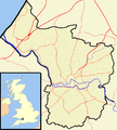
Map of Bristol, England
Article(s): all articles about places listed in Template:Oxford
Request: I have just added infoboxes to almost every article about a neighbourhood in Oxford, England. The Wikipedia convention seems for places in England that are administered by two-tier local government to be to illustrate infoboxes with a map of the whole county. This works well in rural Oxfordshire, but within the City of Oxford the neighbourhoods are so close together that a small map of the whole county fails to show their precise location within the city or their spatial relationship with each other.
Articles about neighbourhoods listed in Template:Bristol have a map showing just Bristol. This is on a larger scale, has more detail and therefore shows the neighbourhoods' locations more clearly. Bristol is a unitary authority so administratively it is no longer in a county. Is there a strict Wikipedia convention that only a unitary authority can have such a map? If not, please may we have a map of Oxford for the infoboxes of districts within Oxford?
Best wishes Motacilla (talk) 11:23, 5 April 2010 (UTC)
Graphist opinion(s):
deforestation in Borneo
[edit]-
map of Borneo to superimpose, without red spot.
Article(s): Borneo - image not there yet.
Request: Hi, I would like to use this map image :File:Borneo deforestation map.jpg in the Borneo article (possibly also creating a Deforestation in Borneo article). My map is derived from the map on this page: maps.grida.no/go/graphic/extent-of-deforestation-in-borneo-1950-2005-and-projection-towards-2020. Can you help me convert it to svp? I would want the outline map of Borneo used, something like this one: :File:Barbourula kalimantanensis on Borneo.svg, but without the red spot! It would need the dates on the original reinstated: 1950 1985 2000 2005 2010 2020 in the appropriate font. Can you help?--Annielogue (talk) 17:30, 5 April 2010 (UTC)
Graphist opinion(s):
2010 Polish Plane Crash - Closeup map
[edit]-
Available image
-
Closeup map to draw
Article(s): 2010 Polish Air Force Tu-154 crash
Request: Hello graphists ! I found an interesting map online about this crazy event. The source to use is the bottom map of this Map as source, plus google.map (satelite view/road view). The Request in to draw the neighbourghood of the Smolensk's Airport, where the plane crashed. The work may be draw using Inkscape, or online on OpenStreetMap. It's for the hot topic of the 2010 Polish Air Force Tu-154 crash~ Yug (talk) 04:13, 13 April 2010 (UTC)
Graphist opinion(s):
Tornado track map
[edit]-
Map of the tornadoes occurring during the 1999 Oklahoma tornado outbreak.
Article(s): To insert in 1999 Oklahoma tornado outbreak
Request: Please create a .svg version. Good luck and thanks in advance, Ks0stm (T•C•G) 19:21, 9 April 2010 (UTC)
Graphist opinion(s): I wouldn't say its impossible to do but that map is so intricate and detailed that it would take a rather long time to draw from scratch as an SVG, regards Fallschirmjäger ✉ 23:10, 15 April 2010 (UTC)
Sakhalin
[edit]Article(s): Sakhalin
Request: crop new version to focus on Sakhalin island, reduce compass rose... Chris (クリス • フィッチュ) (talk) 15:12, 19 April 2010 (UTC)
Graphist opinion(s):
Japanese Empire
[edit]Article(s): Japanese Empire
Request: Change "Pangoon" to Rangoon... Chris (クリス • フィッチュ) (talk) 13:25, 24 April 2010 (UTC)
Graphist opinion(s): Also, is Hainan the wrong colour? And should Hong Kong have a date next to it and/or a different colour? TastyCakes (talk) 13:45, 24 April 2010 (UTC)
remove borders
[edit]-
remove internal border and watermarking
Request: Trim down or remove borders... Chris (クリス • フィッチュ) (talk) 22:08, 25 April 2010 (UTC)
Graphist opinion(s):
African Great Lakes
[edit]Article(s): African Great Lakes
Request: svgify... Chris (クリス • フィッチュ) (talk) 22:09, 25 April 2010 (UTC)
Graphist opinion(s):
French district maps
[edit]-
Administrative divisions of French Guiana
-
Administrative divisions of New Caledonia
Article(s): French Guiana, New Caledonia
Request: Vectorize. Cybercobra (talk) 08:16, 27 April 2010 (UTC)
- Are you looking for the map workshop? --Leyo 13:21, 28 April 2010 (UTC)
- Ah, hadn't noticed that existed. Request moved. --Cybercobra (talk) 18:42, 28 April 2010 (UTC)
Graphist opinion(s):
Japanese exports
[edit]Article(s): Trade policy of Japan
Request: update... Chris (クリス • フィッチュ) (talk) 08:23, 29 April 2010 (UTC)
Graphist opinion(s):
Resolved
[edit]Map
[edit]-
A map
Article(s): Map
Request: Could you add the USA states onto the map? Sophie (Talk) 22:13, 25 May 2010 (UTC)
Graphist opinion(s): Pick one from Commons:Category:Blank maps of the world with subnational borders. /Lokal_Profil 16:19, 28 May 2010 (UTC)
Silk Route
[edit]Article(s): Silk Route
Request: Capitalize "sea"... Chris (クリス • フィッチュ) (talk) 16:34, 15 May 2010 (UTC)
Graphist opinion(s):
![]() Request taken by Splette.: I created a new version. Hope this is an improvement. SPLETTE :] How's my driving? 04:38, 27 May 2010 (UTC)
Request taken by Splette.: I created a new version. Hope this is an improvement. SPLETTE :] How's my driving? 04:38, 27 May 2010 (UTC)
- Cool, thank you, sorry I missed this one!--Chris (クリス • フィッチュ) (talk) 03:46, 24 June 2010 (UTC)
Sperm whale rangemap
[edit]-
SVG
Article(s): Sperm whale
Request: Convert to SVG, use , instead of the blinding shade currently used in the PNG. Thanks. Connormah (talk | contribs) 22:08, 10 June 2010 (UTC)
Graphist opinion(s): This is my first time actually doing something here, so I hope I'm editing appropriately here. Anyway, I'm not up to converting to SVG, but I did change the color to 3F6CFF. Uploaded the file to File:Cetacea range map Sperm Whale 5.png. Pfly (talk) 09:32, 25 June 2010 (UTC)
![]() Done See [1]. 83.81.60.233 (talk) 12:42, 25 June 2010 (UTC)
Done See [1]. 83.81.60.233 (talk) 12:42, 25 June 2010 (UTC)


