Wikipedia:Graphics Lab/Map workshop/Archive/Apr 2015
| This is an archive of past discussions about Wikipedia:Graphics Lab, for the period 2015. Do not edit the contents of this page. If you wish to start a new discussion or revive an old one, please do so on the current main page. |
Commonwealth Republics Map - Gambia and Rwanda
- Article(s)
- Republics in the Commonwealth of Nations
- Request
- Could someone please update this map- Rwanda joined the Commonwealth as a republic in 2009, so it should be coloured in pink to reflect that. And Gambia left the Commonwealth on 3 October 2013, so it should no longer be in pink at all. (And while you're at it, maybe you could also put in the border between Sudan and South Sudan as well, thanks).
- Graphist opinion(s)
![]() Request taken by Rcsprinter123 (jive) @ 11:46, 11 April 2015 (UTC).
Request taken by Rcsprinter123 (jive) @ 11:46, 11 April 2015 (UTC).
![]() Done - File:Commonwealth_republics.svg. Map converted to SVG and Rwanda/Gambia adjustments made, although Sudan border not changed. Rcsprinter123 (prattle) @ 12:01, 11 April 2015 (UTC)
Done - File:Commonwealth_republics.svg. Map converted to SVG and Rwanda/Gambia adjustments made, although Sudan border not changed. Rcsprinter123 (prattle) @ 12:01, 11 April 2015 (UTC)
Nicaraguan Canal and Development Project
- Article(s)
- Nicaraguan Canal and Development Project
- Request
- Hi, any chance someone could crop the excessive white border from this image? I see no reason for it, and it just makes the article layout look odd. 86.152.162.235 (talk) 01:31, 7 April 2015 (UTC)
- Graphist opinion(s)
![]() Done Philg88 ♦talk 07:13, 7 April 2015 (UTC)
Done Philg88 ♦talk 07:13, 7 April 2015 (UTC)
- Thank you! 109.145.180.118 (talk) 17:18, 8 April 2015 (UTC)
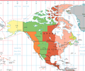
North and Central American Time Zones
- Article(s)
- E.g. Eastern Time Zone
- Request
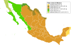
- Hi, if anyone is interested in doing it, the above map needs updating to show the new Southeast time zone in Mexico, per the map below.
- Graphist opinion(s)
- Can you be more specific? What provinces need to be changed into what colour? Wereldburger758 (talk) 15:18, 5 April 2015 (UTC)
- Thanks for your interest. All the necessary information is contained in my description and in the lower map. The new Southeast time zone in Mexico, as shown on the lower map, needs to be incorporated into the upper map. As shown on the legend in the lower map, the new time zone is at UTC −5. The extent of the new time zone is shown on the lower map. 86.152.162.235 (talk) 23:50, 6 April 2015 (UTC)
- I don't quite understand what's happened here. Instead of the new zone being added to the upper map as requested, it seems to have been removed from the lower map, so both maps are now incorrect. 109.153.245.85 (talk) 20:41, 12 April 2015 (UTC)
- @Wereldburger758: It looks to me like a cockup, the sort of thing I sometimes do myself. With luck, Wereldburger758 will be able to reverse it. Maproom (talk) 21:25, 12 April 2015 (UTC)
Okay, I messed this one up. The new Time Zone must be applied to the uppermost map. I did the reverse. I made changes to the lower map according to the information of the uppermost map. I will revert the edited map to the previous one of course.Wereldburger758 (talk) 03:42, 13 April 2015 (UTC)
![]() Done, Wereldburger758 (talk) 04:43, 13 April 2015 (UTC)
Done, Wereldburger758 (talk) 04:43, 13 April 2015 (UTC)
- Thanks, I hate to raise yet another issue with this, but the red line separating -5 and -6 ought to be updated too, so as to join up with the new time zone. 86.152.163.58 (talk) 23:53, 15 April 2015 (UTC)
- Done that, Wereldburger758 (talk) 06:51, 16 April 2015 (UTC)
- Thanks, I hate to raise yet another issue with this, but the red line separating -5 and -6 ought to be updated too, so as to join up with the new time zone. 86.152.163.58 (talk) 23:53, 15 April 2015 (UTC)
Peshawar Drainage Basin 3DEM (Digital Elevation Model)
- Article(s)
- [[]]
- Request
I want the 3DEM of Peshawar Drainage Basin, (Pakistan), as this 3DEM available at File:EN_Bazinul_hidrografic_al_Raului_Latorita,_Romania.jpg
- Peshawar is a city, not a river. It does not have a drainage basin. Rcsprinter123 (chinwag) @ 16:28, 5 April 2015 (UTC)
- Graphist opinion(s)
Question about text in SVG files
If I am creating an SVG file, I check what it looks like in my browser. The fonts my browser uses to render the text in it are presumably determined somewhere under my control.
When I upload the SVG to Commons, some program there renders the SVG into .svg.png files that are served out to the various Wikipedias. This program has some default fonts which are different from the ones my browser uses, so my SVG sometimes looks wrong: pieces of text don't fit in the boxes I drew for them.
A sensible solution would be for me to change my browser's default fonts to the ones the renderer on Commons uses. How can I find out what these are? Maproom (talk) 20:19, 31 March 2015 (UTC)
- You need to convert the text to path in your svg editor so that it will appear the same everywhere. Rcsprinter123 (articulate) @ 20:35, 31 March 2015 (UTC)
- Not necessarily, see c:Help:SVG#Fonts / text and make sure that you use one of the fonts listed there. --Redrose64 (talk) 21:21, 31 March 2015 (UTC)
- Or use this, its a good resource to use! ///EuroCarGT 00:09, 1 April 2015 (UTC)
- Not necessarily, see c:Help:SVG#Fonts / text and make sure that you use one of the fonts listed there. --Redrose64 (talk) 21:21, 31 March 2015 (UTC)
Map for Nanded division and Aurangabad division

The above mentioned articles Nanded division and Aurangabad division are under construction. There is old map of Aurangabad division I have given. Work is very simple, just remove Nanded district, Parbhani district, Hingoli district and Latur district from given map, it will become current valid map of Aurangabad division. Then remove Aurangabad district, Jalna district, Beed district and Osmanabad district from map then it will be a valid map of Nanded division. You can identify districts by clicking on respective district and see location on Wikipedia page of those districts. Thank you. (Hope you understood).--Human3015 Say Hey!! • 15:16, 23 May 2015 (UTC)
Note: Earlier Aurangabad division used to have 8 districts in it as shown in map, but recently new Nanded division having 4 districts is carved out of earlier Aurangabad division, so this map is no more valid now. Now both divisions have 4 districts in it. And it needs map. Maharashtra has total 7 such divisions. --Human3015 Say Hey!! • 04:08, 24 May 2015 (UTC)
- You could make the life of the creators so much easier is you provide a link of an accurate map. Preferrably a SVG-map. But any map will do essentially. It just needs to be accurate.Wereldburger758 (talk) 06:46, 24 May 2015 (UTC)
- Wereldburger758, I have edited this map and posted in respective articles of Aurangabad division(File:Aurangabad division2.png) and Nanded division (File:Nanded division.png). I have posted it as self work as I have done derivative work on basic File:Maharashtra locator map.svg. Can you tell me licensing is OK or not, or can you create acceptable map by seeing images that I have created? Thank you. --Human3015 Say Hey!! • 07:03, 24 May 2015 (UTC)
- If I use a derivitative work, I always take the licence of the original work. That is, in some cases, required. That way I am always on the safe side. So I changed the licences of both works. I also changed the source of both files. I cannot create new files because I don't have the time for that now. But it is not a difficult task. Others can do that for you.Wereldburger758 (talk) 09:50, 24 May 2015 (UTC)
- Thanks..--Human3015 Say Hey!! • 10:34, 24 May 2015 (UTC)


