Wikipedia:Graphics Lab/Illustration workshop/Archive/Feb 2021
Appearance
  | This page, part of the Graphics Lab Wikiproject, is an archive of requests for 2021. Please do not edit the contents of this page. You can submit new requests here. |
SVG flag
-
SVG coa
-
PNG flag
-
SVG flag
- Article(s)
- Lwówek Śląski County
- Request
- Is there someone that could gently make svg of the flag using the svg of the coa? Many thanks in advance!!! -- 93.35.184.189 (talk) 15:16, 11 February 2021 (UTC)
- Discussion
![]() Done Fvasconcellos (t·c) 03:57, 12 February 2021 (UTC)
Done Fvasconcellos (t·c) 03:57, 12 February 2021 (UTC)
Help with this image please
- Article(s)
- Void
- Request
- Please have someone remove the white stripe to the left of the image.
- Erickespinal26 (talk) 20:49, 27 January 2021 (UTC)
- Discussion
![]() Done Auguel (talk) 01:03, 31 January 2021 (UTC)
Done Auguel (talk) 01:03, 31 January 2021 (UTC)
Wikipedia logo resize request
-
Old Norse Wikipedia logo
- Article(s)
- wikipedia:Slogans
- Request
- Is there someone that could gently resize Wikipedia logo to 135x155 px? It will be very appreciated! Thanks in advance!!! -- 37.116.102.74 (talk) 10:04, 23 January 2021 (UTC)
- Discussion
Communist Party of Nicaragua logo
- Article(s)
- Communist Party of Nicaragua
- Request
- Could someone create an SVG version of the logo of the Communist Party of Nicaragua based on its appearance in the upper-left of the election poster provided? -- HapHaxion (talk / contribs) 03:43, 6 March 2021 (UTC)
- Discussion
- @HapHaxion: there is a png on en-wiki (see above) and a svg on ru-wiki: ru:File:PCdeN logo.svg --Mrmw (talk) 16:31, 7 March 2021 (UTC)
- {{resolved}}
Wikipedia logo fix request
-
Wikipedia logo
-
Meitei script Wikipedia logo
- Article(s)
- wikipedia:Slogans
- Request
- Is there someone that could gently fix this Wikipedia logo and resize to 135x155 px? Many thanks in advance!!! --2001:B07:6442:8903:606B:8C21:E6DD:1CAA (talk) 08:38, 4 February 2021 (UTC)
Brandenburg-Prussia
-
Brandenburg-Prussia
-
Map-Germany-1945
-
Locator Brandenburg-Prussia within the Holy Roman Empire (1618)
Can this map of Brandenburg-Prussia (picture No. 1) be drawn against the background of Germany's modern political borders after 1945 (picture No. 2) to understand where she was in relation to modern political boundaries? --Vyacheslav84 (talk) 07:15, 9 February 2021 (UTC)
- Or, in the worst case, instead of figure 1, figure 3. --Vyacheslav84 (talk) 07:27, 9 February 2021 (UTC)
- Article(s)
- Brandenburg-Prussia
- Request
- Discussion
EU Map
-
EU Map
- Article(s)
- List of military and civilian missions of the European Union
- Request
- Please remove the UK from the map as the UK is no longer part of the EU. The C of E God Save the Queen! (talk) 16:57, 17 January 2021 (UTC)
- Discussion
Hi @The C of E: the Falklands would also have to be removed too wouldn't it? Tsange (Talk) 07:59, 10 February 2021 (UTC)
- @Tsange: Yes it would. The C of E God Save the Queen! (talk) 08:17, 10 February 2021 (UTC)
- @The C of E:
 Done Tsange (Talk) 08:59, 10 February 2021 (UTC)
- Thank you. I don't know if it's a technical issue, but when I see it here or click on it the UK is still on it but in the article, it's been updated @Tsange:. The C of E God Save the Queen! (talk) 09:14, 10 February 2021 (UTC)
- @The C of E:
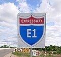
Request Yangon–Mandalay Expressway shield sign
-
YGN-MDY Expressway Sign E1
-
YGN-MDY Expressway Sign E1
- Article(s)
- Yangon–Mandalay Expressway
- Request
- Hello. I would like to request for illustration of YGN-MDY Expressway signboard in svg format if available. Thank you. -- Ninja✮Strikers «☎» 08:43, 14 February 2021 (UTC)
- Discussion


