Wikipedia:Featured picture candidates/Vinland Map
Appearance

- Reason
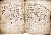
- One of the most controversial documents of the 20th and 21st centuries, the Vinland map has been subject to intense scrutiny and study. If the map is genuine (which Yale University claims and carbon dating backs up) it would prove that the Vikings had reached the new world before Columbus in 1492. The quality is very high, and as Yale guards the map closely, you're not going to find a better picture out there. I put this up for FAC on commons a while ago, voting is still in progress. It may be controversial, but it's high quality and encyclopedic.
- Proposed caption
- The Vinland map is purportedly a 15th century Mappa Mundi, redrawn from a 13th century original and owned by Yale University. Drawn with black ink on animal skin, the map is the first known depiction of the North American coastline, created before Columbus' 1492 voyage. The upper left caption reads: “By God's will, after a long voyage from the island of Greenland to the south toward the most distant remaining parts of the western ocean sea, sailing southward amidst the ice, the companions Bjarni and Leif Eiriksson discovered a new land, extremely fertile and even having vines, ... which island they named Vinland.”
- Articles this image appears in
- Vinland Map
- Creator
- Yale University, uploaded by Jeff Dahl
- Support as nominator Jeff Dahl 05:24, 14 October 2007 (UTC)
- Support Nice scan. So what's the current thinking about this? Authentic? Debivort 06:21, 14 October 2007 (UTC)
- Yale originally had it authenticated in the 50-60s. In the 70s, microscopy analysis suggested the ink was modern, so the tide turned against. In the 90s and 2000s, XRF analysis suggested the microscopy results were not valid. Then another analysis disputed the XRF analysis. It goes back and forth. Pretty much everyone who's done an analysis had one agenda or another going into the work, and many have claimed that his or her discovery is the "definitive" proof one way or the other. TV shows, news reports, and even scientific journals are not immune to the aggrandizing claims and POV pushing, the need to tell a story, etc. One thing that would put a lot of the controversy to rest is finding out the map's provenance; the original owner refused to say where it came from (because it was either a forgery, or smuggled out of a major European rare book library). So in other words, it's disputed. Jeff Dahl 17:02, 14 October 2007 (UTC)
 Support Exceptionally good scan and very nice. Cat-five - talk 06:34, 14 October 2007 (UTC)
- Comment Just a technicality, but this map doesn't "prove" that the Vikings reached North America; that is handily taken care of by us finding their houses in Newfoundland. Matt Deres 14:54, 14 October 2007 (UTC)
- If it's authentic, it proves that news reached home, which in some ways is ultimately more significant. Chick Bowen 01:38, 16 October 2007 (UTC)
- This was known from the Sagas though. de Bivort 04:42, 16 October 2007 (UTC)
- If it's authentic, it proves that news reached home, which in some ways is ultimately more significant. Chick Bowen 01:38, 16 October 2007 (UTC)
- Support Forgery or not, it is sufficiently interesting to be FP. The "wow" lies in the caption - the thumb as such is not so wewy wowwy. (You may notice I am a fan of animated cartoons... ;-) --Janke | Talk 18:32, 15 October 2007 (UTC)
- Support although I think the caption is perhaps dull. Half of what makes this map fascinating is the nagging sense that it's a fake. (As Matt Deres points out, the map isn't by itself proof of anything one way or the other. L'Anse aux Meadows upstaged this map in more ways than one.) --Dhartung | Talk 20:07, 15 October 2007 (UTC)
- I get what you mean. I've been thinking about a revised caption, here is a start, but I'll think it over some more. Jeff Dahl 17:03, 16 October 2007 (UTC)
- Proposed revised caption: "The Vinland map is purportedly a 15th century Mappa Mundi, redrawn from a 13th century original. Drawn with black ink on animal skin, the map is the first known depiction of the North American coastline, created before Columbus' 1492 voyage. Although the parchment has been radiocarbon dated to the mid 1400s, the map, now owned by Yale University, has no known provenance before the 20th century. Scientific study has yielded conflicting results, and the authenticity of the map is hotly debated.”
- weak oppose It's obviously encyclopedic and the scan is of decent quality, but this just doesn't look like a featured picture to me. A crudely drawn map done in plain black of dirty white just doesn't have any visual appeal - and I actually love looking at old maps. Just too boring. Matt Deres 01:02, 18 October 2007 (UTC)
- I agree it isn't a Rembrandt, but allow me to quote from the FP criteria: "A featured picture is not always required to be aesthetically pleasing; it might be shocking, impressive, or just highly informative. Highly graphic, historical and otherwise unique images may not have to be classically beautiful at all" this map's special quality is its historical importance and the controversy over its authenticity. Jeff Dahl (Talk • contribs) 01:19, 18 October 2007 (UTC)
 Support Good value and tech detail.--Beyond silence 14:00, 19 October 2007 (UTC)
- Support Historic value. And its nice to see the caption acknowledged the disputes related to the picture, rather than arguing over the accuracy of the image here. —Preceding unsigned comment added by Snowolfd4 (talk • contribs) 22:30, 19 October 2007 (UTC)
Promoted Image:Vinland Map HiRes.jpg MER-C 04:50, 20 October 2007 (UTC)
