Wikipedia:Featured picture candidates/Hispaniola
Appearance

- Reason
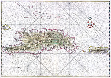
- This seems to be the month for correcting systemic bias about the Caribbean. This time another of Johannes Vingboons's seventeenth century maps. High ev, and just fascinating to work with these detailed manuscript maps. Restored version of File:Hispaniola Vinckeboons.jpg. See also compressed courtesy copy at File:Hispaniola Vinckeboons4 courtesy copy.jpg (for slower connection speeds).
- Articles this image appears in
- History of the Dominican Republic, Hispaniola, Captaincy General of Santo Domingo
- Creator
- Johannes Vingboons
- Support as conominator --Durova278 16:58, 14 July 2009 (UTC)
- Support as conominator —Ynhockey (Talk) 17:04, 14 July 2009 (UTC)
- Support –Juliancolton | Talk 17:57, 14 July 2009 (UTC)
- Support - --Anhamirak 21:28, 14 July 2009 (UTC)
- Support - --Kumioko (talk) 23:32, 14 July 2009 (UTC)
- Support Noodle snacks (talk) 00:56, 15 July 2009 (UTC)
- Support GerardM (talk) 02:11, 15 July 2009 (UTC)
- Support per nom. --Caspian blue 03:22, 15 July 2009 (UTC)
- Support My computer almost exploded from trying to open this, but it was worth it. Great quality and good EV in the history article. Makeemlighter (talk) 04:40, 19 July 2009 (UTC)
- Support high encyclopedic value and an appealing restoration. Ottava Rima (talk) 00:29, 21 July 2009 (UTC)
Promoted File:Hispaniola Vinckeboons4.jpg --wadester16 06:28, 22 July 2009 (UTC)
