Wikipedia:Featured picture candidates/Cape of Good Hope
Appearance

- Reason
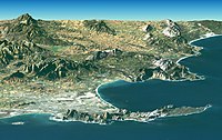
- Featured on German wikipedia. Interesting combination of satellite photography and mapping software. The image page has a more detailed caption in Afrikaans, which I can't read. (Astute readers of the last few noms may have noticed that I am mining the German wikipedia's version of FP-- this isn't cheating, is it?
- Proposed caption
- This perspective-view image of the South African city of Cape Town and its environs around the Cape of Good Hope, including Table Bay (at the lower left), and Table Mountain, a 1,086 meter (3,563-foot) tall sandstone and granite natural landmark. The image was generated by combining NASA satellite imagery with elevation data collected from the Shuttle Radar Topography Mission (SRTM).
- Articles this image appears in
- Cape Town, Table Mountain, Table Bay, Cape Peninsula, Sunday Times Golden Globe Race
- Creator
- NASA
- Support as nominator Spikebrennan 22:28, 12 October 2007 (UTC)
- "[T]his isn't cheating, is it?" Not really. Most of the stuff that gets featured on de or commons should be featured here as well. In fact, I'd like to see more mining of COM:FPC and COM:QIC (the latter to PPR), but I can't really afford to do that - who's going to close the nominations? MER-C 03:13, 13 October 2007 (UTC)
- As is frequently pointed out, commons has different FP standards. The foreign-language wikipedias theoretically don't. Also, is there any easy way of seeing, on commons, whether a particular image is used in wikipedia articles? On the commons image pages, the only links that I see are to other commons pages. Spikebrennan 21:01, 15 October 2007 (UTC)
- Oppose strong aliasing at the skyline and other places. The colors seem to be under a white veil. (Not sure what the technical term is for this) Jeff Dahl 03:36, 13 October 2007 (UTC)
- Oppose per Jeff Dahl, and the vertical axis is too exaggerated for my tastes. Debivort 04:48, 13 October 2007 (UTC)
- Per [1]: This Landsat and SRTM perspective view uses a 2-times vertical exaggeration to enhance topographic expression. The back edges of the data sets form a false horizon and a false sky was added. Colors of the scene were enhanced by image processing but are the natural color band combination from the Landsat satellite. The caption can be fixed to indicate that there is 2x vertical exaggeration-- does this really spoil the image? Spikebrennan 20:58, 15 October 2007 (UTC)
- Oppose per Jeff Dahl. --Hirohisat 紅葉 06:01, 13 October 2007 (UTC)
Not promoted MER-C 09:09, 19 October 2007 (UTC)
