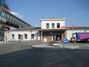
Wien Liesing railway station
Appearance
This article needs additional citations for verification. (April 2015) |
| S-Bahn and Regional rail station | ||||||||||||||||||||
 | ||||||||||||||||||||
| General information | ||||||||||||||||||||
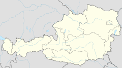
| Location | Liesingerplatz 1 Austria | |||||||||||||||||||
| Coordinates | 48°08′05″N 16°17′02″E / 48.13472°N 16.28389°E | |||||||||||||||||||
| Owned by | Austrian Federal Railways | |||||||||||||||||||
| Platforms | 1 side platform, 1 Island platform | |||||||||||||||||||
| Tracks | 3 | |||||||||||||||||||
| Construction | ||||||||||||||||||||
| Parking | 365 spaces[1] | |||||||||||||||||||
| Bicycle facilities | 59 spaces[1] | |||||||||||||||||||
| Accessible | Yes | |||||||||||||||||||
| Other information | ||||||||||||||||||||
| Fare zone | Core Zone (100) | |||||||||||||||||||
| History | ||||||||||||||||||||
| Opened | 1841 | |||||||||||||||||||
| Electrified | 15 kV 16,7 Hz | |||||||||||||||||||
| Services | ||||||||||||||||||||
| ||||||||||||||||||||
| ||||||||||||||||||||
Wien Liesing is a railway station in the 23 district of Vienna. The station is located 7 km (4.3 mi) southwest of Meidling station and is served by S-Bahn and most ÖBB Regional trains. The station was opened in 1841 along with the Southern Railway. The history Liesing brewery has been converted in 2010 to a shopping mall and is one block west of the station.[2]
Station Layout
[edit]| Track 3 | ← S2 toward Wolkersdorf/Mistelbach/Laa an der Thaya, S3 toward Stockerau/Hollabrunn, S4 toward Stockerau/Absdorf-Hippersdorf/Tullnerfeld, R 500 and R 510 toward Wien Floridsdorf |
| Island platform | |
| Track 2 | → S2, S3 and S4 toward Mödling/Wiener Neustadt → |
| Track 1 | → R 500 toward Payerbach-Reichenau, R 510 toward Wienener Neustadt → |
| Side platform | |
Connections
[edit]City Buses
[edit]- 60A Liesing — Alterlaa
- 61A Liesing — Vösendorf-Siebenhirten
- 62A Liesing — Bhf. Meidling/Eichenstraße
- 64A Liesing — Hetzendorf
- 66A Liesing — Reumannplatz
References
[edit]- ^ a b ÖBB Reiseportal Station information - Wien Liesing - www.oebb.at
- ^ Bundesdenkmalamt: Dehio - The historical monuments of Austria, Vienna, S.720.

