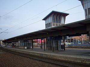
Wien Erzherzog-Karl-Straße railway station
Appearance
 The Marchegger Ostbahn platforms in 2009 | |||||||||||||||||||||
| General information | |||||||||||||||||||||
| Location | Vienna Austria | ||||||||||||||||||||
| Coordinates | 48°13′47.11″N 16°27′11.38″E / 48.2297528°N 16.4531611°E | ||||||||||||||||||||
| Owned by | ÖBB | ||||||||||||||||||||
| Line(s) | |||||||||||||||||||||
| Platforms | 2 island platforms | ||||||||||||||||||||
| Tracks | 4 | ||||||||||||||||||||
| Train operators | ÖBB | ||||||||||||||||||||
| Connections | |||||||||||||||||||||
| Services | |||||||||||||||||||||
| |||||||||||||||||||||
| |||||||||||||||||||||
Wien Erzherzog-Karl-Straße is a railway station serving Donaustadt, the twenty-second district of Vienna.[1] The station is a keilbahnhof located at the junction of the Laaer Ostbahn and Marchegger Ostbahn lines. It has an island platform on each line, although at present no passenger trains use the Laaer Ostbahn north of the station.
Services
[edit]As of the December 2020 timetable change,[update] the following services stop at Wien Erzherzog-Karl-Straße:[2]
- Regionalzug (R): hourly service between Wien Hauptbahnhof and Marchegg.
- Vienna S-Bahn S80: half-hourly service between Wien Hütteldorf and Wien Aspern Nord.
References
[edit]- ^ "Stationsinformation". fahrplan.oebb.at. Retrieved 2020-01-02.
- ^ "Marchegger Ostbahn & S80" (PDF) (in German). ÖBB. 13 December 2020. Retrieved 6 August 2021.
External links
[edit] Media related to Bahnhof Wien Erzherzog-Karl-Straße at Wikimedia Commons
- Wien Erzherzog-Karl-Straße railway station – ÖBB

