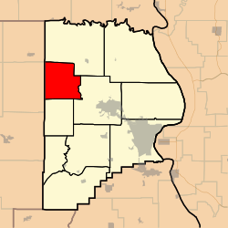
Whitewater Township, Cape Girardeau County, Missouri
Whitewater Township | |
|---|---|
 | |
| Coordinates: 37°27′10″N 089°48′16″W / 37.45278°N 89.80444°W | |
| Country | United States |
| State | Missouri |
| County | Cape Girardeau |
| Area | |
• Total | 36.5 sq mi (94.54 km2) |
| • Land | 36.45 sq mi (94.41 km2) |
| • Water | 0.05 sq mi (0.13 km2) 0.14% |
| Elevation | 443 ft (135 m) |
| Population (2000) | |
• Total | 1,263 |
| • Density | 34.7/sq mi (13.4/km2) |
| FIPS code | 29-79630[2] |
| GNIS feature ID | 0766404 |
Whitewater Township is one of ten townships in Cape Girardeau County, Missouri, USA. As of the 2000 census, its population was 1,263.
History
[edit]Whitewater Township was founded in 1852.[3] The township took its name from the Whitewater River.[4]
Geography
[edit]Whitewater Township covers an area of 36.5 square miles (95 km2) and contains no incorporated settlements. Known cemeteries include Baker, Bollinger Family Cemetery at Bollinger Mill, Born, Caney Fork – New and Old, Estes, Ferguson, Gladish, Kurre, Kurreville/Maintz, Limbaugh, Mayfield, Miller at Millersville, Niswonger New and Old, Old Salem Methodist, Riehn, Schmidt, Snider, Wilkerson 1 and 2, Wise.
The streams of Caney Fork, Crawford Creek, Dry Creek, Little Muddy Creek, Panther Creek, Sandy Branch and Wolf Creek run through this township.
References
[edit]- ^ "US Board on Geographic Names". United States Geological Survey. October 25, 2007. Retrieved January 31, 2008.
- ^ "U.S. Census website". United States Census Bureau. Retrieved January 31, 2008.
- ^ History of Southeast Missouri: A Narrative Account of Its Historical Progress, Its People and Its Principal Interests, Volume 1. Lewis Publishing Company. 1912. p. 163.
- ^ "Cape Girardeau County Place Names, 1928–1945 (archived)". The State Historical Society of Missouri. Archived from the original on June 24, 2016. Retrieved September 10, 2016.
External links
[edit]

