West Chester State College Quadrangle Historic District
West Chester State College Quadrangle Historic District | |
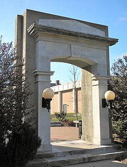
 Old Main Entry, West Chester State College Quadrangle Historic District, January 2010 | |
| Location | Bounded by S. High and S. Church Sts., College and Rosedale Aves., West Chester, Pennsylvania |
|---|---|
| Coordinates | 39°57′08″N 75°35′55″W / 39.95222°N 75.59861°W |
| Area | 12.6 acres (5.1 ha) |
| Built | 1891-1940 |
| Architect | Multiple |
| Architectural style | Colonial Revival, Classical Revival, Other, Collegiate Gothic |
| NRHP reference No. | 81000539[1] |
| Added to NRHP | October 8, 1981 |
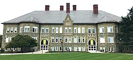
West Chester State College Quadrangle Historic District, also known as the Quadrangle Historic District, is a group of historic academic buildings and national historic district located on the campus of West Chester University of Pennsylvania in West Chester, Chester County, Pennsylvania. It consists of five contributing buildings built between 1891 and 1940. They are Recitation Hall (1891-1893), the former Model School (1899, Ruby Jones Hall), the Old Library (1902-1904), Philips Memorial Building (1925-1927), and Anderson Hall (1937-1940). Except for Philips and Anderson, these buildings are all constructed of native Chester County serpentine stone.[2]
It was listed on the National Register of Historic Places on October 8, 1981 for its significance in architecture and education.[2]
Gallery
[edit]-
Recitation Hall
-
Anderson Hall
References
[edit]- ^ "National Register Information System". National Register of Historic Places. National Park Service. November 2, 2013.
- ^ a b Webster, Richard J. "NRHP Nomination Form: West Chester State College Quadrangle Historic District" (PDF). National Park Service – via CRGIS: Cultural Resources Geographic Information System for Pennsylvania.
Includes 62 photos


