Wessin
Appearance
Wessin | |
|---|---|
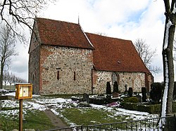
 Church | |
| Coordinates: 53°34′N 11°44′E / 53.567°N 11.733°E | |
| Country | Germany |
| State | Mecklenburg-Vorpommern |
| District | Ludwigslust-Parchim |
| Town | Crivitz |
| Subdivisions | 3 |
| Area | |
• Total | 17.07 km2 (6.59 sq mi) |
| Elevation | 58 m (190 ft) |
| Population (2009-12-31) | |
• Total | 438 |
| • Density | 26/km2 (66/sq mi) |
| Time zone | UTC+01:00 (CET) |
| • Summer (DST) | UTC+02:00 (CEST) |
| Postal codes | 19089 |
| Dialling codes | 03863 |
| Vehicle registration | PCH |
| Website | http://www.amt-crivitz.de/ |
Wessin is a village and a former municipality in the Ludwigslust-Parchim district, in Mecklenburg-Vorpommern, Germany. The village is rural and the main land use within the boundary is farming.[1]
History
[edit]On the northern edge of the village is the stone church, which dates from the 12th century AD.[2]
The grounds of the Kurzzeitpflege am Tulpenbaum former manor house contain one of Germany's largest and oldest specimens of Liriodendron tulipifera, at approx 32 metres (105 ft) in height.[2]
The former municipality included the villages of Badegow and Radepohl. Since 1 January 2011, all three villages are administratively part of the town Crivitz.[2]
References
[edit]- ^ "Wessin, Crivitz, Germany". Google Maps. Retrieved 18 April 2022.
- ^ a b c "Unsere Ortsteile: Wessin" (in German). Stadt Crivitz. Retrieved 18 April 2022.


