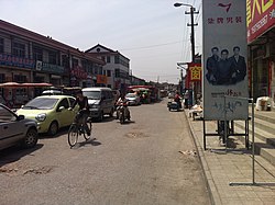
Wangqingtuo
Wangqingtuo Town
王庆坨镇 | |
|---|---|
 Sijie Village in Wangqingtuo Town | |
| Coordinates: 39°10′51″N 116°53′55″E / 39.18083°N 116.89861°E | |
| Country | |
| Municipality | Tianjin |
| District | Wuqing |
| Village-level Divisions | 2 community 22 villages |
| Area | |
| • Total | 56.11 km2 (21.66 sq mi) |
| Elevation | 9 m (30 ft) |
| Population (2010) | |
| • Total | 45,016 |
| • Density | 800/km2 (2,100/sq mi) |
| Time zone | UTC+8 (CST) |
| Postal code | 301713 |
| Area code | 022 |
Wangqingtuo Town (simplified Chinese: 王庆坨镇; traditional Chinese: 王慶坨鎮; pinyin: Wángqìngtuó Zhèn) is a town located in the southwest of Wuqing District, Tianjin, China. It borders Geyucheng and Chagugang Towns to its north, Shuangkou and Yangliuqing Towns to its east, Yangfengang Town to its south, and Donggugang Town to its west. The town had a census population of 45,016 as of 2010.[1]
Geography
[edit]Wangqingtuo Town lies on the southeast of the Zhonghong Ancient Channel, with Beijing–Shanghai Expressway and Rongwu Expressway passing through it. The town is located at an altitude of 9 meters above the sea level.[2]
History
[edit]| Year | Status | Belongs to |
|---|---|---|
| 1957–1958 | Wangqingtuo Township | Wuqing County, Hebei |
| 1958–1973 | Wangqingtuo People's Commune | |
| 1973–1983 | Wuqing County, Tianjin | |
| 1983–1988 | Wangqingtuo Township | |
| 1988–2000 | Wangqingtuo Town | |
| 2000–present | Wuqing District, Tianjin |
Administrative divisions
[edit]As of 2022, Wangqingtuo Town had direct jurisdiction over 24 subdivisions, consisting of these 2 residential communities and 22 villages:[4]
Residential communities
[edit]- Xinjiayuan (鑫嘉园)
- Mingshi Jiayuan (名仕佳苑)
Villages
[edit]- Yijie (一街)
- Erjie (二街)
- Sanjie (三街)
- Sijie (四街)
- Wujie (五街)
- Liujie (六街)
- Qijie (七街)
- Bajie (八街)
- Jiujie (九街)
- Daogouzi (道沟子)
- Wang'erdian (王二淀)
- Sihezhuang (四合庄)
- Dafankou (大范口)
- Xiaofankou (小范口)
- Zhengjialou (郑家楼)
- Daliuzi (大柳子)
- Fuxingzhuang (复兴庄)
- Da Sanhezeng (大三河曾)
- Xiao Sanhezeng (小三河曾)
- Zhangjiadi (张家地)
- Caijiadi (蔡家地)
- Youzhangbu (尤张堡)
See also
[edit]References
[edit]- ^ "China: Tiānjīn Municipal Province (Districts and Townships) - Population Statistics, Charts and Map". www.citypopulation.de. Retrieved 2023-07-13.
- ^ "Wangqingtuo topographic map, elevation, terrain". Topographic maps. Retrieved 2023-07-13.
- ^ 中华人民共和国政区大典 天津卷 [Collection of Administrative Divisions of the People's Republic of China, Tianjin Volumn] (in Chinese) (Di 1 ban ed.). 2020. ISBN 978-7-5087-6215-9. OCLC 1351675957.
- ^ "2022年统计用区划代码和城乡划分代码" [2022 Statistical Division Codes and Urban-rural Differentiation Codes]. www.stats.gov.cn (in Chinese). Archived from the original on 2023-03-21. Retrieved 2023-07-13.


