Wakapuaka
Appearance
(Redirected from Wakapuaka Sandflats Esplanade)
Wakapuaka | |
|---|---|
Town | |
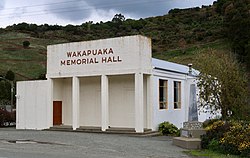
 Wakapuaka Memorial Hall | |
 | |
| Coordinates: 41°12′20″S 173°21′10″E / 41.20556°S 173.35278°E | |
| Country | New Zealand |
| Region | Nelson |
Wakapuaka is a small township lying to the north of Nelson, New Zealand. It lies on State Highway 6 inland from the northern end of Nelson Haven, between Marybank and Hira. The road to Glenduan joins SH 6 at Wakapuaka.[1][2]
Parks
[edit]Wakapuaka Sandflats Esplanade, a local public park area, is located in Wakapuaka.[3]
Demographics
[edit]Wakapuaka is part of the Nelson Rural statistical area.[4]
References
[edit]- ^ Reed New Zealand atlas (2004) Auckland: Reed Publishing. Map 59. ISBN 0 7900 0952 8
- ^ Wise's Nelson-Blenheim "Easyread" Map ISBN 1 877402 50 8
- ^ "Nelson Parks and Reserves". gdc.govt.nz. Gisborne District Council.
- ^ 2018 Census place summary: Nelson Rural
