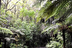
Waipoua Settlement
Appearance
Waipoua Settlement | |
|---|---|
 Waipoua Forest | |
| Coordinates: 35°56′18″S 173°52′18″E / 35.93833°S 173.87167°E | |
| Country | New Zealand |
| Region | Northland Region |
| District | Kaipara District |
| Postcode(s) | 0310 |
Waipoua Settlement is a rural community in the Kaipara District of Northland, in New Zealand's North Island.
It includes the Waipoua Forest, one of the best preserved examples of a kauri forest in New Zealand.[1][2] It is notable for having two of the largest living kauri trees, Tāne Mahuta and Te Matua Ngahere. Approximately 200,000 people visit Tāne Mahuta every year.[3]
The area has two marae belonging to Te Roroa:[4] Matatina Marae and Tuohu meeting house, and Pananawe Marae and Te Taumata o Tiopira Kinaki meeting house.[5]
Notes
[edit]- ^ Alicia Burrow (6 May 2015). "Kaipara leads the way in 'visitor' growth". Stuff.co.nz. Retrieved 23 November 2018.
- ^ "Waipoua Forest: Places to go in Northland". Department of Conservation. Retrieved 23 November 2018.
- ^ "Waipoua Forest: Places to go in Northland". Department of Conservation. Retrieved 23 November 2018.
- ^ "Te Kāhui Māngai directory". tkm.govt.nz. Te Puni Kōkiri.
- ^ "Māori Maps". maorimaps.com. Te Potiki National Trust.
35°56′S 173°53′E / 35.933°S 173.883°E

