Volunteer Landing
| Volunteer Landing | |
|---|---|
 | |
 | |
| Type | Public park, riverwalk |
| Location | 300 Neyland Drive, Knoxville, Tennessee |
| Coordinates | 35°57′31″N 83°55′01″W / 35.958733°N 83.916817°W |
| Created | 1997 |
| Owned by | City of Knoxville |
| Operated by | Knoxville Public Building Authority |
| Open | Dawn to dusk unless posted otherwise |
| Public transit access | KAT 10, 11, 17 |
| Website | Official website |
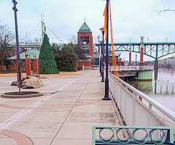
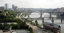
Volunteer Landing is a public park and riverwalk along the Tennessee River in Knoxville, Tennessee.[1][2] It is below the Gay Street Bridge.[1]
History
[edit]The location of the park is the site of the Treaty of Holston.[3] In 1988, a 50-member waterfront task force was created to analyze the waterfront area along the Tennessee River.[3][4] Per the recommendations of this task force, a three-phase project to develop Volunteer Landing began in 1995 and continued through 1996.[3][4] Volunteer Landing was completed in September 1997.[5] Upon this completion, Volunteer Landing had a boardwalk, a central pavilion and plaza, a pedestrian bridge, and two new public parks.[5] In April 1999, Gateway Regional Visitor Center which highlighted the region's nature and technology was opened.[5] In Spring 2000, the 140-boat slip Volunteer Landing Marina, was completed.[5] The Regas Riverfront Tavern/Restaurant, which seated about 250 people and had a banquet facility with capacity of 300, was also completed in 2000, concluding the waterfront development project.[5]
The state and local government contributed $10 million to Volunteer Landing.[5] The marina was funded with about $3 million in private funds and a $100,000 Tennessee Wildlife Resources Agency (TWRA) grant.[5] The visitor center was received $5.6 million in federal, state, and local funds.[5] The tavern/restaurant had about $6 million of private funding.[5] The overall cost was $42 million and consisted of both public and private developments.[4]
In 2007, the Public Building Authority began to manage Volunteer Landing.[3]
Description
[edit]
Volunteer Landing has 13 acres (5.3 ha).[6] Two new public parks were built as part of Volunteer Landing.[4] One is called River Mountain Park, and it is west of the central pavilion and demonstrates the region's river and mountain heritage through the landscaping and water features.[4] The second park is at the mouth of First Creek where the city was founded and has exhibits reflecting this history.[4]
Volunteer Landing Park is a three-acre linear park connects James White Greenway and Neyland Greenway.[7] They are part of the downtown greenway system which is 19 miles long and runs east to west.[6]
Activities
[edit]The one-mile walk features several attractions such as train rides, riverboat cruises, restaurants, and a marina.[1]
Fishing, biking, walking/running, and paddling are some available activities.[7] During University of Tennessee (UT) home football games, the Vol Navy lines the river at Volunteer Landing as part of a tailgating tradition.[7][6] There is also a playground, splash pads, a shelter, picnic areas, and restrooms available.[1][7]
Docks
[edit]
One dock was originally built for the 1982 World's Fair.[6] In 2017, a privately owned boat hit the dock and damaged it.[6] It was closed afterwards, though the city had already planned improvements prior to the incident.[6] The replacement dock cost $270,000 and 75 percent was financed by a TWRA grant.[6] In April 2018, city-owned 360-foot-long boat dock reopened.[6]
The Vol Navy dock is near Neyland Stadium.[8] The dock and concrete pavilion were built 1994 and was funded by a TWRA grant.[8] In 1998, 200 feet were added.[8] In 2019, the new dock was completed.[8] It is nearly 600 feet long.[8] The TWRA funded the project with a $400,000 grant and $100,000 came from the city and UT.[8] The Public Building Authority managed the project.[8] The city owns the dock and UT maintains it.[8]
References
[edit]- ^ a b c d Huso, D. (2010). Moon Blue Ridge & Smoky Mountains. Moon Blue Ridge and Smoky Mountains. Avalon Publishing. p. 276. ISBN 978-1-59880-532-1. Retrieved 2020-07-24.
- ^ Molloy, J. (2011). Five-Star Trails: Knoxville: Your Guide to the Area's Most Beautiful Hikes. Five-Star Trails. Menasha Ridge Press. p. 33. ISBN 978-0-89732-922-4. Retrieved 2020-07-24.
- ^ a b c d "Volunteer Landing". World's Fair Park Knoxville. Retrieved 2020-07-29.
- ^ a b c d e f "Knoxville Waterfront Development". About Knoxville. Retrieved 2020-07-29.
- ^ a b c d e f g h i Knoxville/Knox County, Tennessee Empowerment Zone (September 20, 2010). Knoxville/Knox County, Tennessee Empowerment Zone, Empowerment Zones / Enterprise Communities, Annual Report, July 1, 2009 – July 2, 2010 (PDF) (Report). Retrieved 2020-07-31.
- ^ a b c d e f g h "City-owned dock at Volunteer Landing reopens". Knoxville News Sentinel. 2018-04-20. Retrieved 2020-07-30.
- ^ a b c d "Volunteer Landing". Visit Knoxville TN. 2014-08-30. Retrieved 2020-07-29.
- ^ a b c d e f g h "New Vol Navy dock opens in time for first Tennessee home game". wbir.com. 2019-08-30. Retrieved 2020-07-30.
