Vernal Fall
| Vernal Fall | |
|---|---|
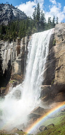
 Vernal Fall from Mist Trail | |
 | |
| Location | Yosemite Valley, Yosemite National Park, California |
| Coordinates | 37°43′39″N 119°32′38″W / 37.727426°N 119.543773°W |
| Type | Plunge |
| Total height | 317 feet (97 m) |
| Number of drops | 1 |
| World height ranking | 860 |
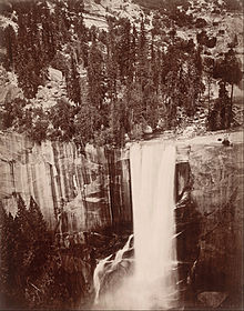
Vernal Fall is a 317-foot (96.6 m) waterfall on the Merced River just downstream of Nevada Fall in Yosemite National Park, California.[1][2] Like its upstream neighbor, Vernal Fall is clearly visible at a distance, from Glacier Point, as well as close up, along the Mist Trail. The waterfall flows all year long, although by the end of summer it is substantially reduced in volume and can split into multiple strands, rather than a single curtain of water.
History
[edit]

Etymology
[edit]Yan-o-pah (little cloud) was the local name of the fall before it was named "Vernal"- meaning relating to Spring - by Lafayette Bunnell, a member of the Mariposa Battalion in 1851.[3][4]
Mist Trail
[edit]The trail begins at the Happy Isles trail head in Yosemite Valley and travels generally east-southeast. This is one of the shortest (1.3 mi or 2.1 km) and most popular trails in Yosemite. The trail is mostly shaded and is progressive in incline until it reaches the base of the waterfall where mist sprays onto the hikers.
At times of high flow, mostly in the spring, hikers may be drenched by the time they pass the mist from the waterfall. The final 15 minutes of the trail is a very steep climb up rocks to the top of the waterfall. Once atop the fall there is a pool of water called the Emerald Pool around which hikers lounge and rest. There is also a 20 degree slope of rock with water flowing into the pool called the Silver Apron.
Hazards
[edit]
Swimming above Vernal Fall carries a great deal of risk: the rocks are slippery, the river has strong undercurrents that may not be visible from the surface, and tourists have been swept over the fall to their deaths.[5] Though swimming there is illegal[6] and warnings to stay out of the water are clearly posted, several deaths have occurred when visitors entered the water above the fall in the vicinity of the Silver Apron and Emerald Pool. Three people died in a single day, on July 19, 2011, after being swept over Vernal Fall in this manner.[7]
Postage stamp
[edit]The fall is shown in error on a 1932 Philippines stamp. Although the stamp indicates that it depicts Pagsanjan Falls in the Philippines, it in fact shows Vernal Fall.[8]
References
[edit]- ^ N. King Huber. "The Geologic Story of Yosemite Valley". USGS Western Region Geologic Information. Archived from the original on 2005-11-11. Retrieved 2005-09-20.
- ^ The official name is singular, see U.S. Geological Survey Geographic Names Information System: Vernal Fall
- ^ Farquhar, Francis P. (1926). "V - Vernal Fall". Place Names of the High Sierra. San Francisco: Sierra Club. OCLC 2871447.
- ^ Bunnell, Lafayette Houghton (2003) [1880]. Discovery of the Yosemite and the Indian War of 1851 Which Led to That Event. Washington, D.C.: Library of Congress, National Digital Library Program. OCLC 51675913. Retrieved 2009-01-05.
- ^ NBC News
- ^ "Vernal Fall and Nevada Fall Trails - Yosemite National Park (U.S. National Park Service)".
- ^ Brad Knickerbocker (July 21, 2011). "Yosemite waterfall accident a cautionary tale for Yosemite visitors". The Christian Science Monitor. Retrieved July 21, 2011.
- ^ Kloetzel, Joseph, ed. (August 2007). Scott 2008 Standard Postage Stamp Catalogue. Vol. 5. Sidney, OH: Scott catalogue. pp. 231. ISBN 978-0-89487-399-7.
External links
[edit]- Place Names of the High Sierra, "V", Francis Farquhar
- United States Geological Survey. "Topographical Map for 37.7274262, -119.5437725". Retrieved 2008-07-05.
- View a short video embedded in Google Maps

