Veriora Parish
Appearance
Veriora Parish
Veriora vald | |
|---|---|
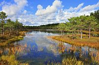
 Meenikunno bog | |
 Veriora Parish within Põlva County | |
| Country | |
| County | |
| Administrative centre | Veriora |
| Area | |
• Total | 200.37 km2 (77.36 sq mi) |
| Population (01.01.2017) | |
• Total | 1,350 |
| • Density | 6.7/km2 (17/sq mi) |
Veriora Parish (Estonian: Veriora vald) was a rural municipality of Estonia, in Põlva County. It had a population of 1350 (as of 2017) and an area of 200.37 km².[1] In 2017, Veriora Parish, Räpina Parish and Meeksi Parish were merged and a new municipality Räpina Parish was formed.
Settlements
[edit]- Small borough
- Villages
Haavapää - Himmiste - Jõevaara - Jõeveere - Kikka - Kirmsi - Koolma - Koolmajärve - Kullamäe - Kunksilla - Laho - Leevi - Lihtensteini - Männisalu - Mõtsavaara - Nohipalo - Pahtpää - Sarvemäe - Soohara - Süvahavva - Timo - Väike-Veerksu - Vändra - Vareste - Verioramõisa - Viira - Viluste - Vinso - Võika
References
[edit]- ^ "Population figure and composition". Statistics Estonia. Retrieved 19 September 2020.


