Vafs Rural District
Appearance
Vafs Rural District
Persian: دهستان وفس | |
|---|---|
| Coordinates: 34°48′03″N 49°22′05″E / 34.80083°N 49.36806°E[1] | |
| Country | Iran |
| Province | Markazi |
| County | Komijan |
| District | Central |
| Capital | Komijan |
| Population (2016)[2] | |
• Total | 8,038 |
| Time zone | UTC+3:30 (IRST) |
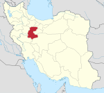
Vafs Rural District (Persian: دهستان وفس) is in the Central District of Komijan County, Markazi province, Iran. It is administered from the city of Komijan.[3]
History
[edit]Vafs Rural District was created in the Central District after the 2006 National Census.[3]
Demographics
[edit]Population
[edit]At the time of the 2011 census, the rural district's population was 8,816 in 2,736 households.[4] The 2016 census measured the population of the rural district as 8,038 in 2,644 households. The most populous of its 22 villages was Samqavor, with 2,107 people.[2]
See also
[edit]References
[edit]- ^ OpenStreetMap contributors (31 August 2023). "Vafs Rural District (Komijan County)" (Map). OpenStreetMap (in Persian). Retrieved 31 August 2023.
- ^ a b "Census of the Islamic Republic of Iran, 1395 (2016)". AMAR (in Persian). The Statistical Center of Iran. p. 00. Archived from the original (Excel) on 17 October 2020. Retrieved 19 December 2022.
- ^ a b Rahimi, Mohammad Reza (11 November 1388). "Approval letter of reforms and divisional changes in Markazi province". SOLH (in Persian). Ministry of Interior, Board of Ministers. Archived from the original on 19 January 2024. Retrieved 19 January 2024.
- ^ "Census of the Islamic Republic of Iran, 1390 (2011)". Syracuse University (in Persian). The Statistical Center of Iran. p. 00. Archived from the original (Excel) on 19 January 2023. Retrieved 19 December 2022.


