Větřní
Větřní | |
|---|---|
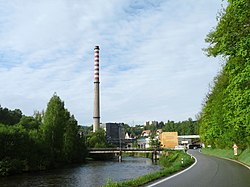
 Větřní paper mill | |
| Coordinates: 48°44′19″N 14°29′47″E / 48.73861°N 14.49639°E | |
| Country | |
| Region | South Bohemian |
| District | Český Krumlov |
| First mentioned | 1347 |
| Government | |
| • Mayor | Antonín Krák |
| Area | |
• Total | 27.71 km2 (10.70 sq mi) |
| Elevation | 592 m (1,942 ft) |
| Population (2024-01-01)[1] | |
• Total | 3,821 |
| • Density | 140/km2 (360/sq mi) |
| Time zone | UTC+1 (CET) |
| • Summer (DST) | UTC+2 (CEST) |
| Postal code | 381 01, 382 11 |
| Website | www |
Větřní (German: Wettern) is a town in Český Krumlov District in the South Bohemian Region of the Czech Republic. It has about 3,800 inhabitants.
Administrative parts
[edit]The villages of Dobrné, Hašlovice, Lužná, Nahořany, Němče, Zátoň and Zátoňské Dvory are administrative parts of Větřní.
Geography
[edit]Větřní is located about 4 kilometres (2 mi) southwest of Český Krumlov and 25 km (16 mi) southwest of České Budějovice. It lies in the Bohemian Forest Foothills. The highest point is the Plešivec hill at 862 m (2,828 ft) above sea level. The town is situated on the left bank of the Vltava River.
History
[edit]The first written mention of Větřní is from 1347. The oldest part is the village of Němče, first mentioned in 1293. Větřní began to rapidly grow from 1870, when a paper mill was established.[2]
In 2017, Větřní obtained the town status.[3]
Demographics
[edit]
|
|
| ||||||||||||||||||||||||||||||||||||||||||||||||||||||
| Source: Censuses[4][5] | ||||||||||||||||||||||||||||||||||||||||||||||||||||||||
Economy
[edit]Větřní is known for a paper mill, which is one of the major paper producents in the Czech Republic. It is located near the Vltava.[2]
Transport
[edit]A railway runs through the municipal territory, but there is no passenger transport.
Sights
[edit]
The oldest building is the Church of Saint John the Baptist in Zátoň. It was built in the late Gothic style in the 1490s. The second notable building is the Church of Saint John of Nepomuk, a modern church built in 1936–1938.[6]
Twin towns – sister cities
[edit] Lotzwil, Switzerland
References
[edit]- ^ "Population of Municipalities – 1 January 2024". Czech Statistical Office. 2024-05-17.
- ^ a b "Historie města Větřní" (in Czech). Město Větřní. Retrieved 2022-07-07.
- ^ Houska, Jan (2017-02-01). "Lidé z Větřní už nežijí v obci, ale ve městě". Českokrumlovský deník (in Czech). Retrieved 2021-09-03.
- ^ "Historický lexikon obcí České republiky 1869–2011" (in Czech). Czech Statistical Office. 2015-12-21.
- ^ "Population Census 2021: Population by sex". Public Database. Czech Statistical Office. 2021-03-27.
- ^ "Památkové objekty v katastru města" (in Czech). Město Větřní. Retrieved 2022-07-07.
- ^ "Vetrni" (in German). Lotzwil. Archived from the original on 2020-08-09. Retrieved 2020-08-12.


