User talk:Gaff/Map request
To help me create a quick and accurate species map for a page, please include the following in your request:
- Article name(s): for which the map will be used on,
- Source(s): a link to the (publication or website) in which the map data is shown,
- Base map: link to a background map if you have one chosen (review for free license)
- Comments: a description of the surrounding region you would like displayed on the map,
- whether you would like me to add the map to the article or post here for discussion,
- any other details, such as color choices, subspecies highlights, etc.
Thank you, Gaff

Sources for data
[edit]Possible base maps:
[edit]-
option A
-
option B
-
option C
-
option D, best yet?
Comments
[edit]
- My current preference is option C since clearly sourced, and SVG format easy to work with in InkScape. This can be blown up to highlight the region of interest with a thumbnail of the continent in the corner for reference, similar to those on my Userpage. --Gaff (talk) 16:33, 3 March 2015 (UTC)
- I'll build it with option C with a format similar to the map I made for Long-billed thrasher if you are okay with that. As for color of the highlighted area, I will look around unless you have a preference. We can keep it green if you like. --Gaff (talk) 16:41, 3 March 2015 (UTC)
- Changed my mind. I like D better. --Gaff (talk) 16:48, 3 March 2015 (UTC)
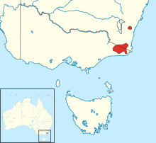
- @Casliber: Draft is up. The data set shows the region in the northwest, which it sounds like might be disputed territory? I can remove it or put in in as a different color. I can also easily change the zoom window, color etc.
- Thanks very much for doing the map. It's looking great! The dot in NW Victoria is from a single record of a cultivated specimen, so it should be removed. I like option D, and I like that it is now a square format and not elongated. I like the green for the distribution aesthetically speaking, but I think red would give a better contrast, especially as viewed on the inset map The Atlas of Living Australia mapping info needs to be used with caution, because it has some records of cultivated plants and also coordinates of some data (especially from old records) that is very imprecise. Perhaps the map linked from The Flora Of Australia online should be used as a source? .--Melburnian (talk) 19:53, 3 March 2015 (UTC)
- @Gaff: - I just emailed you a better map than the flora one - the map is from page 6 of the following:
- Thanks very much for doing the map. It's looking great! The dot in NW Victoria is from a single record of a cultivated specimen, so it should be removed. I like option D, and I like that it is now a square format and not elongated. I like the green for the distribution aesthetically speaking, but I think red would give a better contrast, especially as viewed on the inset map The Atlas of Living Australia mapping info needs to be used with caution, because it has some records of cultivated plants and also coordinates of some data (especially from old records) that is very imprecise. Perhaps the map linked from The Flora Of Australia online should be used as a source? .--Melburnian (talk) 19:53, 3 March 2015 (UTC)
- M.D.Crisp & P.H.Weston, Waratahs – how many species?, in J.A.Armstrong (ed.), Waratahs – their Biology, Cultivation and Conservation 3–15 (1987); P.H.Weston & M.D.Crisp, Evolution and biogeography of the Waratahs, in J.A.Armstrong (ed.), Waratahs – their Biology, Cultivation and Conservation 17–34 (1987);
- Mike Crisp and Peter Weston are the foremost experts on the genus and have done loads of work. I like the base map you chose. If you have time and want to play, feel free to do a map for Telopea truncata and Telopea mongaensis as we might buff them to GA at some point soon as well...cheers, Cas Liber (talk · contribs) 23:02, 3 March 2015 (UTC)
- @Casliber: is that one reference or two that you provided. It looks like two. Is the correct one "Waratahs – how many species"? or "Evolution and biogeography of the Waratahs" --Gaff (talk) 00:22, 5 March 2015 (UTC)
- Crisp and Weston wrote the chapter entitled "Waratahs – how many species?" in hte book "Waratahs – their Biology, Cultivation and Conservation" edited by J.A. Armstrong. I think I double clicked the cut and paste above :P Cas Liber (talk · contribs) 01:35, 5 March 2015 (UTC)
- @Casliber: is that one reference or two that you provided. It looks like two. Is the correct one "Waratahs – how many species"? or "Evolution and biogeography of the Waratahs" --Gaff (talk) 00:22, 5 March 2015 (UTC)
- Mike Crisp and Peter Weston are the foremost experts on the genus and have done loads of work. I like the base map you chose. If you have time and want to play, feel free to do a map for Telopea truncata and Telopea mongaensis as we might buff them to GA at some point soon as well...cheers, Cas Liber (talk · contribs) 23:02, 3 March 2015 (UTC)
- @Casliber:, @Melburnian: better? It would also be easy to make a color coded version of the different species in the genus on all the same map. I think having a separate map for each species helps add some clarity as well. --Gaff (talk) 04:08, 4 March 2015 (UTC)
- Looks good - thanks! Perhaps the inset of Australia map should be made bigger?--Melburnian (talk) 04:23, 4 March 2015 (UTC)
- (edit conflict) Yes. much. A map with all 5 species would be fantastic for the waratah page - on the genus, which at some point would be good to go through and get all the references inlined...and all single species maps for hte single species pages. cheers, Cas Liber (talk · contribs) 04:24, 4 March 2015 (UTC)
- @Melburnian: I made the inset larger and increased the width of the bounding boxes. I'm open to any other advice for improvements. --Gaff (talk) 08:05, 6 March 2015 (UTC)
- That's great. Thanks very much for taking this on.--Melburnian (talk) 10:50, 6 March 2015 (UTC)
- My pleasure. I will work on the other maps in the near future. Let me know if you need them sooner. --Gaff (talk) 18:55, 6 March 2015 (UTC)
- That's great. Thanks very much for taking this on.--Melburnian (talk) 10:50, 6 March 2015 (UTC)
- @Melburnian: I made the inset larger and increased the width of the bounding boxes. I'm open to any other advice for improvements. --Gaff (talk) 08:05, 6 March 2015 (UTC)
- (edit conflict) Yes. much. A map with all 5 species would be fantastic for the waratah page - on the genus, which at some point would be good to go through and get all the references inlined...and all single species maps for hte single species pages. cheers, Cas Liber (talk · contribs) 04:24, 4 March 2015 (UTC)
- Looks good - thanks! Perhaps the inset of Australia map should be made bigger?--Melburnian (talk) 04:23, 4 March 2015 (UTC)

- Sources for data
- Possible base maps
- Comments
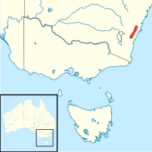
@Melburnian:, @Casliber:: Here is a draft. I think it should be fine, but let me know if you want it tweaked. The color is a bit intense. I will let you two decide where in the article to place it (taxobox vs distribution section). Cheers --Gaff (talk) 04:18, 28 March 2015 (UTC)
- Colour works well - the border offsets it nicely. cheers, Cas Liber (talk · contribs) 05:01, 28 March 2015 (UTC)
- Great, thanks--Melburnian (talk) 11:42, 28 March 2015 (UTC)

- Sources for data
- Possible base maps
- Comments
- @Melburnian:, @Casliber:: Let me any adjustments needed on this one as well. --Gaff (talk) 05:00, 28 March 2015 (UTC)
- Looks fine to me. thanks! Cas Liber (talk · contribs) 05:02, 28 March 2015 (UTC)
- And me, thanks again. --Melburnian (talk) 11:45, 28 March 2015 (UTC)
- Sources for data
- Possible base maps
- Comments
Carolina Wren map
[edit]
- Comments
- Hi! You can do the map just like you've done the others, and I'll check on the page to see if its up. I think that you have the link, so I guess I'll leave you to it. Thanks! LeftAire (talk) 21:23, 9 March 2015 (UTC)
- @LeftAire: Here is is. I'm not sure how I feel about it, but its a start. At least the sourcing is clear, which is important, especially for FA. Let me know if you have feedback. --Gaff (talk) 05:08, 10 March 2015 (UTC)
- It's looks fine. A fine job as usual to me. What do you think is wrong with it? The color?? LeftAire (talk) 21:56, 10 March 2015 (UTC)
- I think you're right. It's fine. I was having some problems getting InkScape to do what I needed and this map wound up taking a lot longer than it should have. When things like that happen, it just makes it all feel a bit off. But let's leave it like this for now... --Gaff (talk) 22:10, 10 March 2015 (UTC)
- It's looks fine. A fine job as usual to me. What do you think is wrong with it? The color?? LeftAire (talk) 21:56, 10 March 2015 (UTC)
- @LeftAire: Here is is. I'm not sure how I feel about it, but its a start. At least the sourcing is clear, which is important, especially for FA. Let me know if you have feedback. --Gaff (talk) 05:08, 10 March 2015 (UTC)
This article was promoted several years ago. The subspecies have been split into six rather than two. Seven colours are needed as there is an interzone area in western Victoria. I originally used an all-Australia map but we could get away with a southeastern Aust plus Tasmania map. Source to use for new map is here - page 91 or 92. Just thought you might be up for a 7-coloured challenge :) cheers, Cas Liber (talk · contribs) 00:38, 5 May 2015 (UTC)
- I've been on a break, but will get to this soon. If delay is too long, you can post at the Map Lab as well. --Gaff (talk) 20:09, 6 May 2015 (UTC)
- No dramas...just thought you'd like a challenge :) Cas Liber (talk · contribs) 01:40, 7 May 2015 (UTC)


