Jump to content

User:WOSlinker/Infobox for Briarcliff Manor, New York

From Wikipedia, the free encyclopedia

Differences between Geobox and Infobox

[edit]
Geobox|Settlement Infobox settlement

{{Geobox|Settlement}}

Briarcliff Manor, New York
Village of Briarcliff Manor
Founded byWalter William Law
Highest elevation
(41°09′24″N 73°50′46″W / 41.15667°N 73.84611°W / 41.15667; -73.84611)
162 m (533 ft)
Lowest elevation0 m (0 ft)

Note: Besides the inclusion and exclusion of certain parameters, there are formatting issues.

  • The caption for the main image has no spacing above it.
  • The symbol and seal have no editable names (and the symbol is not a flag).
  • The nickname and motto use "(s)" which is not ideal.
  • The font size for all parameters appears slightly bigger, taking up more space.
  • The maps appear much further up, which is far from ideal.

-- ɱ (talk) · vbm · coi) 18:37, 4 November 2018 (UTC)

@: -- I'm going to copy these proposals to Talk:Briarcliff Manor, New York, so we can reach a consensus with all interested editors. —hike395 (talk) 20:45, 4 November 2018 (UTC)


Full comparison between Geobox and Infobox

[edit]
Geobox|Settlement Infobox settlement

{{Geobox|Settlement}}

Briarcliff Manor, New York
Village of Briarcliff Manor
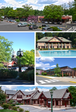
A medley of different scenes to represent the diversity of the village. At top is a photo of a street on the village's business district. Above center, right shows the Village Pool as part of Law Memorial Park. Below center, right shows Briarcliff Manor's high school. At the bottom is the village library, part of which was once Briarcliff's train station. Center, left shows the central business district with Briarcliff Manor's pocket park and clock in the foreground, and the old Municipal Building in the background.
Clockwise from top: the Village Center; village pool at Law Memorial Park; Briarcliff High School; Briarcliff Manor Public Library; village clock and Municipal Building.
Coat of arms of Briarcliff Manor, New York
Etymology: The Irish family home "Brier Cliff"
Nickname: 
Briarcliff
Motto: 
A Village between Two Rivers
Located against the Hudson River, with Routes 9, 9A, 100, and the Taconic State Parkway traversing the village.
Boundaries of and major thoroughfares through Briarcliff Manor.
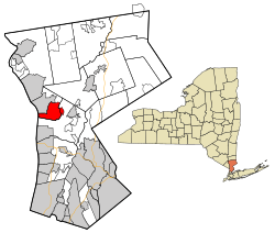
Located on the west border of the county, in the center by latitude. The county is located in the south section and on the east border of the state.
Location of Briarcliff Manor within Westchester County and the county within New York.
Coordinates: 41°8′24″N 73°50′24″W / 41.14000°N 73.84000°W / 41.14000; -73.84000
CountryUnited States
StateNew York
RegionHudson Valley
CountyWestchester
MunicipalityMount Pleasant and Ossining
Settled1890s
Incorporation1902
Founded byWalter William Law
SeatBriarcliff Manor Village Hall, 1111 Pleasantville Road, 41°08′56″N 73°49′43″W / 41.14889°N 73.82861°W / 41.14889; -73.82861
PartsChilmark and Scarborough
Government
 • MayorLori A. Sullivan (People's Caucus)
 • Board
Trustees
  • Cesare J. DeRose, Jr.
  • Mark Pohar
  • Mark L. Wilson
  • Bryan Zirman
Area
 • Total
6.7 sq mi (17 km2)
 • Land5.9 sq mi (15 km2)
 • Water0.8 sq mi (2 km2)
Elevation
351 ft (107 m)
Highest elevation533 ft (162 m)
Lowest elevation0 ft (0 m)
Population
 (2010)
 • Total
7,867
 • Density1,200/sq mi (450/km2)
Time zoneUTC−5 (EST)
 • Summer (DST)UTC−4 (EDT)
ZIP Code
10510
Area code914
FIPS code36-08103
GNIS feature ID969912, 2391558
VIAF codeVIAF 130216697
Websitewww.briarcliffmanor.org