User:Utahweather
Who I Am
[edit]I am a senior at the University of Utah studying meteorology.
Why I'm Here
[edit]I am working on a meteorology assignment to improve the content of Wikipedia.
The University of Utah Meteorology Program
[edit]For more information about the University of Utah Meteorology Program, click here
Mesowest
[edit]For current weather conditions for thousands of weather stations across the country, click here
A Little About Wikipedia Articles
[edit] Featured Articles: Articles that Wikipedia editors believe are the best articles in Wikipedia.
A-Class Articles: Articles that provide a well-written, reasonably clear and complete description of the topic.
GA-Class Articles: Articles that still need some work to reach featured article standards, but that are otherwise good.
B-Class Articles: Articles that have significant gaps or missing elements or references, needs substantial editing for English language usage and/or clarity, balance of content, or contains other policy problems such as copyright, Neutral Point Of View (NPOV) or No Original Research (NOR).
Start-Class Articles: Articles that have good content, but still are weak in many areas, and may lack a key element.
Stub-Class Articles: Articles that are either very short or a rough collection of information that will need much work to bring it to A-Class level.
Meteo 5140 Homework 9-- Bow Echoes
[edit]What is in Wikipedia Already
[edit]A bow echo is a term used to describe a squall line of thunderstorms that has a characteristic shape of an archer's bow. They can produce severe straight-line winds with some embedded tornadoes or gustnadoes. Especially strong bow echos that can cause devastating damage all along the width of the storm are often called derechos.[1]
Proposed Expansion of Information
[edit]What is a Bow Echo?
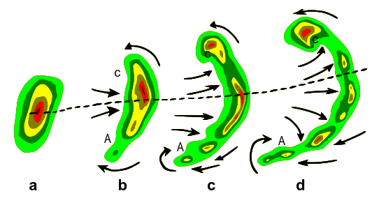
[edit]A bow echo is a term used to describe a squall line of thunderstorms that has a characteristic shape of an archer's bow. The bow echo commonly evolves from either a single convective cell or a line of cells into a comma-shaped echo. Bow echoes have been observed to occur over a wide range of sizes while evolving from a diverse set of morphologies. Especially strong bow echoes can cause devastating straight line winds.
What are its features?
[edit]Key structural features include a rear-inflow jet bringing in air into the core of the bow, with book-end or line-end vortices on both sides of the rear-inflow jet, behind the ends of the bowed convective segment. Early on in its evolution, both cyclonic and anticyclonic book-end vortices tend to be of similar strength, but later in the evolution, the northern cyclonic vortex often dominates, giving the convective system a comma-shaped appearance.[2]
How big are Bow Echoes and how long do they last?
[edit]Bow echoes have been observed with scales between 20 and 200 km, and often have lifetimes between three and six hours.
How does a Bow Echo form?
[edit]Bow echoes usually occur with a grouping of multicell storms that are arranged into a squall line. The upper tropospheric winds steer storms. These winds help determine the speed and direction that the storms move. The upper tropospheric winds will not always be constant along a squall line. In the regions these winds are stronger that portion of the squall line will surge forward. Also, in regions these winds are drier that portion of the squall line will surge forward because evaporational cooling creates negative buoyancy that will further accelerate a downdraft toward the surface. Since the downdraft from a squall line approaches the earth's surface at an angle, the faster the downdraft winds the faster the storms may migrate forward.[3]

Where do the strongest and most damaging winds occur in a Bow Echo?
[edit]Damaging straight-line winds often occur near the center of a bow echo. To give you an idea of how much damage can occur from a bow echo, damage from all severe thunderstorm winds account for half of all severe reports in the lower 48 states and is more common than damage from tornadoes. Wind speeds can reach up to 100 mph (160 km/hr) and can produce a damage path extending for hundreds of miles.[4] Bow Echoes are capable of producing straight-line that are just as strong. Also, Bow Echoes create a favorable environment for tornadoes to form. If you hear that a Bow Echo is heading your way, watch out; the damage could be deadly.
References
[edit]
| This user is a member of WikiProject Meteorology. |
