User:Therealtred/sandbox
Appearance
Nothing here right now. Just for me to mess around with
Pretty cool sandbox here
| Developer(s) | Foursquare |
|---|---|
| Operating system | iOS, Android, Windows Phone 8.1 |
| Cedar Fire | |
|---|---|
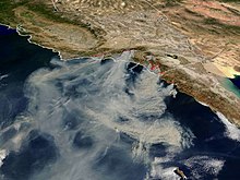
 A dozen simultaneous wildfires in October 2003; the Cedar Fire is the large one just to the right of the center of the picture | |
| Date(s) | October 25, 2003 – December 5, 2003 17:37 (PDT) |
| Location | San Diego County, California |
| Coordinates | 33°1′N 116°41′W / 33.017°N 116.683°W |
| Statistics | |
| Burned area | 280,278 acres (1,134.2 km2)[1][2] |
| Land use | Mixed, residential and wildlands |
| Impacts | |
| Deaths | 15 |
| Non-fatal injuries | 113 total[1][3] |
| Damage | $27 million (2003 USD)[1] |
| Company type | Public company AG |
|---|---|
| SIX: NOVN, NYSE: NVS | |
| Industry | Pharmaceuticals |
| Founded | 1996 (from merger) |
| Headquarters | Basel, Basel-Stadt, Switzerland |
Key people | Joerg Reinhardt (Chairman), Joseph Jimenez (CEO) |
| Products | Pharmaceuticals, generic drugs, over-the-counter drugs, vaccines, diagnostics, contact lenses, animal health (list...) |
| Revenue | |
| Total assets | |
| Total equity | |
Number of employees | |
| Subsidiaries | Ciba Vision, Sandoz, Alcon, Chiron Corporation |
| Website | www |
- ^ a b c Cedar Fire & Memorial, Lakeside Historical Society
- ^ Cedar Fire-Final Update, State of California website. (Note: some references, such as [1] report the area as 273,246 acres (1,105.8 km2); however, this article uses the figure reported by the State of California.)
- ^ http://cdfdata.fire.ca.gov/incidents/incidents_details_info?incident_id=57
- ^ a b c d e f "Novartis Annual Report 2013". Novartis. Archived from the original (PDF) on 5 June 2012. Retrieved 15 May 2014.
