User:Tavantius/sandbox6
| Timeline of the 2023 Pacific typhoon season | |||||
|---|---|---|---|---|---|
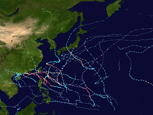
 Season summary map | |||||
| Season boundaries | |||||
| First system formed | March 4, 2023 | ||||
| Last system dissipated | December 18, 2023 | ||||
| Strongest system | |||||
| Name | Mawar | ||||
| Maximum winds | 215 km/h (130 mph) (10-minute sustained) | ||||
| Lowest pressure | 900 hPa (mbar) | ||||
| Longest lasting system | |||||
| Name | Khanun | ||||
| Duration | 13 days | ||||
| |||||
This timeline documents all of the events of the 2023 Pacific typhoon season. Most of the tropical cyclones form between May and November. The scope of this article is limited to the Pacific Ocean, north of the equator between 100°E and the International Date Line. Tropical storms that form in the entire Western Pacific basin are assigned a name by the Japan Meteorological Agency while tropical depressions that form in this basin are given a number with a "W" suffix by the United States' Joint Typhoon Warning Center. In addition, the Philippine Atmospheric, Geophysical and Astronomical Services Administration (PAGASA) assigns names to tropical cyclones (including tropical depressions) that enter or form in the Philippine area of responsibility. These names, however, are not in common use outside of the Philippines.
During the season, 29 systems were designated as tropical depressions by either the Japan Meteorological Agency (JMA), the Philippine Atmospheric, Geophysical and Astronomical Services Administration (PAGASA), the Joint Typhoon Warning Center (JTWC), or other National Meteorological and Hydrological Services such as the China Meteorological Administration and the Hong Kong Observatory. As they run the Regional Specialized Meteorological Centre for the Western Pacific, the JMA assigns names to tropical depressions should they intensify into a tropical storm. PAGASA also assign local names to tropical depressions which form within their area of responsibility; however, these names are not in common use outside of PAGASA's area of responsibility.
Timeline
[edit]
January
[edit]January 1
- 00:00 UTC — The 2023 Pacific typhoon season officially begins.
March
[edit]March 4
- 06:00 UTC at 2°N 107°E / 2°N 107°E ― The Japan Meteorological Agency notes that a tropical depression with a minimum pressure of 1,012 hPa (29.9 inHg) formed east of Singapore.[1]
March 5
- 06:00 UTC at 3°N 109°E / 3°N 109°E ― The Japan Meteorological Agency issues their last advisory on the tropical depression as it simultaneously attains an initial minimum pressure of 1,010 hPa (30 inHg).[2]
March 6
- 06:00 UTC at 3°06′N 109°12′E / 3.1°N 109.2°E ― The Japan Meteorological Agency notes that the tropical depression regenerated and attained a minimum pressure of 1,018 hPa (30.1 inHg).[3]
March 7
- 12:00 UTC at 3°N 110°E / 3°N 110°E ― The Japan Meteorological Agency issues their last advisory on the weakening tropical depression.[4]
April
[edit]April 10
- 00:00 UTC at 12°N 135°E / 12°N 135°E ― The Japan Meteorological Agency notes that a tropical depression with a minimum pressure of 1,008 hPa (29.8 inHg) formed well east of the Philippines.[5]
- 20:00 UTC (04:00 PHT on April 11) at 13°18′N 138°36′E / 13.3°N 138.6°E ― As the depression is located in their area of responsibility, the Philippine Atmospheric, Geophysical, and Astronomical Services Administration (PAGASA) issues their first advisory on Tropical Depression Amang 475 km (295 mi) east of Virac, Philippines.[6]
April 11
- 00:00 UTC at 13°42′N 126°42′E / 13.7°N 126.7°E ― The Japan Meteorological Agency issues their first prognostic reasoning on Amang, noting that it had intensified to attain maximum sustained winds of 35 mph (55 km/h) and a minimum pressure of 1,004 hPa (29.6 inHg).[7]
- 15:00 UTC (23:00 PHT) at 13°54′N 124°18′E / 13.9°N 124.3°E ― PAGASA notes that Amang made its first landfall over Panganiban, Catanduanes with sustained winds of 35 mph (55 km/h) and a minimum pressure of 1,006 hPa (29.7 inHg).[8]
References
[edit]- ^ "Warning and Summary 040600". Japan Meteorological Agency. 4 March 2023. Retrieved 4 March 2023.
- ^ "Warning and Summary 050600". Japan Meteorological Agency. 5 March 2023. Retrieved 5 March 2023.
- ^ "Warning and Summary 060600". Japan Meteorological Agency. 6 March 2023. Retrieved 6 March 2023.
- ^ "Warning and Summary 071200". Japan Meteorological Agency. 7 March 2023. Retrieved 7 March 2023.
- ^ "Warning and Summary 100000". Japan Meteorological Agency. April 10, 2023. Retrieved April 10, 2023.
- ^ "Tropical Cyclone Bulletin #1 for Tropical Depression 'Amang'" (PDF). PAGASA. 10 April 2023. Archived from the original (PDF) on 10 April 2023. Retrieved 10 April 2023.
- ^ "Prognostic Reasoning No. 1 for TD located at 13.7°N 126.7°E". Japan Meteorological Agency. April 11, 2023. Retrieved April 11, 2023.
- ^ "Tropical Cyclone Bulletin #4 for Tropical Depression 'Amang'" (PDF). PAGASA. 11 April 2023. Archived from the original (PDF) on 11 April 2023. Retrieved 11 April 2023.
