User:Sreed16
Tectontonic subsidence is the act of the earth's crust sinking relative to neighboring crust or point of reference.[1]. Components of plate movement create several environments in which subsidence occurs including, passive margins, aulacogens, fore-arc basins, foreland basins, intercontinental basins, and pull apart basins, and are largely accommodated by faulting.[2] Three mechanisms: extension, cooling, and loading, are common in the tectonic environments in which subsidence occurs.[3]
Mechanisms
[edit]Extension
[edit]
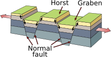
Extensional tectonics is accomplished by normal faulting or larger scale rifting, where the lithosphere undergoes horizontal extension. The crust will stretch until faulting occurs creating systems of normal faults,either horst and grabens or listric faults. These fault systems allow the region to increase its width by decreasing its thickness. As the crust is stretched it thins subsequently subsides over time relative the thicker undeformed crust by gravitational equilibrium or isostasy.[3]
Cooling
[edit]
At areas of crustal thinning the mantle is allowed to melt by decompression and the asthenosphere is allowed to rise closer to the surface which heats the overlying plates by processes of conduction and advection from intrusive igneous formations. Heating of the lithosphere decreases its density and uplifts the crust due to buoyancy of the heated and deformed crust compared to the undeformed cooler crust. Once the thinning is complete the heated portion of the crust slowly cools and becomes heavier causing subsidence.[4]
Loading
[edit]Loading is adding weight over an area by sedimentation or orogenic processes which causes crustal depression and subsidence. Sediments from erosion accumulate in lowest elevation possible due to gravity,these areas are called accommidation spaces[3]. The rate and magnitude of accumulation controls the rate at which subsidence occurs. Orogeny is the process of mountain building which creates massive loads on the earth’s surface causing flexural depressions in the adjacent lithosphere[3].
Environments
[edit]Passive margins
[edit]
Passive margins, like the gulf coast of the United States, are transition regions from continental to oceanic plates where there is no active plate boundary. These margins are created by old successful rifts overlaid by sediment. The formation of passive margins begins with extension of crust due to rifting of two continental plates, as the plates move the crust thins and subsides.[2]The asthenosphere, moving towards the surface as the crust thins, sequentially heats the overlying crust making it less dense. Accumulation of non-marine sediment forms alluvial fans in the low-lying area. Continuous rifting creates listric fault systems and further subsidence resulting in the creation of an oceanic basin and corresponding sea creating marine sediment deposits. Once the rifting ceases the crust subsides further due to cooling, and continued sedimentation accumulates on top of the ocean basin compounding the subsidence[4].
Aulacogens
[edit]Aulacogens, like the environment in Quebec, Canada, are a product of failed rifts in which the continent doesn’t completely split. Similar to formation of passive margins, subsidence occurs as a product of lithospheric thinning due to spreading forces of continental plates. As spreading occurs sedimentation occurs applying a load on the region. Once the tensional forces cease subsidence continues due to cooling.[3]
Foreland Basins
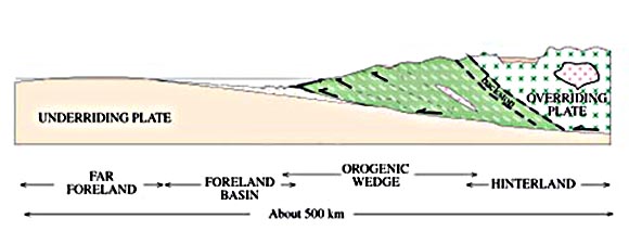
[edit]Foreland basins are flexural depressions created by large fold thrust sheets that form toward the undeformed continent, these occur regularly east of the Rocky Mountians. Foreland basin subsidence is attributed to the isostatic response of the lithosphere from an orogenic load, basin growth is controlled by load migration and corresponding sedimentation[2]. There is increased subsidence in the adjacent basin as the load migrates along with delayed subsidence in the basin further foreland and is seen in higher magnitudes with broader basins. The basins give accommidation space for sediment eroded from the fold thrust sheet with thickening sediment layers toward the thrust belt and thinning layers away from the thrust belt creating differential subsidence.[5]
Intracontinental Basins
[edit]

Intracontinental basins are large areal depression that is tectonically inactive and is not located in the proximity of any plate boundaries.[3] These basins experience long-lived and slow subsidence and occur all over the world.[2] It is generally thought that this subsidence is a product of long-term cooling since the break-up of Pangea, however there is long standing debate. Other hypotheses state that the long term subsidence is a product of interaction of deformation around the basins’ edge. There are others who believe that subsidence is driven by more deep earth dynamics.[6]
Pull apart basins
[edit]Pull Apart basins have relatively short lived subsidence that form from transtension strike-slip faults. Moderate strike-slip faults create extensional releasing bends and opposing walls pull apart from each other. Normal faults occur which induces small scale subsidence in the area and ceases once the fault stops propagating.[3] A larger scale version is a pull-apart basins, like the Los Angelos Basin, larger magnitude extension occurs causing lithospheric thinning, sediments fill the basin and cooling occurs after the fault ceases to propagate.[2]
Forearc basins
[edit]Forearc basins are formed when oceanic plate subducts under a less dense continental plate. As the two plates collide sediment is scraped off the subducting oceanic plate forming an acrectionary wedge between the subducting oceanic plate and a sliver of oceanic plate, like what occurred in the Central Valley of California. Between this wedge and the volcanic arc there is a sea floor depression zone.[3] There is several poorly understood mechanisms varying from basin to basin. Extension and extensional faulting occurs by relative motions between acrectionary wedge and volcanic arc. Abnormal cooling effects from the subducting oceanic plate and crustal thinning due to tectonic erosion and underplating are also thought to be occurring.[7]
References
[edit]- ^ American Geophysical Union. Subsidence. 19 June 2006. http://www.agu.org/report/hurricanes/subsidence.html. 17 October 2011
- ^ a b c d e Xie Xiangyang and Heller, Paul. Plate tectonics and basin subsidence history. Geological Society of America Bulletin. v. 121, no. 1-2, p. 55-64. January 2009. http://gsabulletin.gsapubs.org/content/121/1-2/55.full.
- ^ a b c d e f g h Van der Plu, Ben A., Marshak, Stephen. Earth Stucture: An introduction to Structural Geology and Tectonics. 2004. W. W. Norton & Company Inc.
- ^ a b Department of Earth Sciences: University of Oxford. The Subsidence of the Passive Continental Margins. 30 September 2008. http://www.earth.ox.ac.uk/research/groups/marine/ the_subsidence_history_of_passive_continental_margins. 17 October 2011
- ^ Mascle Alain and Puigdefàbregas Cai. Tectonics and Sedimentation in Foreland Basins: results from the Intergrated Basin Studies Project. Geologic Society. 2008. http://sp.lyellcollection.org/content/134/1/1.full.pdf. 17 October 2011
- ^ Herbert, John Haid. Tectonic Subsidence anaylsis of the Willidiston Basin. University of Saskatchewan. 1991. http://library2.usask.ca/theses/available/etd-02012011-125432/.
- ^ Scholl, David W. Basal Subduction Erosion and the Formation of the Aleutian Terrace and Underlying Forearc Basin. Whole Woods oceanographic institution. 28 Februray 2008. http://www.whoi.edu/page.do?pid=20415&tid=282&cid=37947. 17 October 2011.


