User:OWL/New London, Connecticut
| This is a Wikipedia user page. This is not an encyclopedia article or the talk page for an encyclopedia article. If you find this page on any site other than Wikipedia, you are viewing a mirror site. Be aware that the page may be outdated and that the user in whose space this page is located may have no personal affiliation with any site other than Wikipedia. The original page is located at https://en.wikipedia.org/wiki/User:OWL/New_London,_Connecticut. |
City of New London | |
|---|---|
 | |
| Nickname: The Whaling City | |
| Motto: | |
 | |
| Coordinates: 41°21′20″N 72°05′58″W / 41.35556°N 72.09944°W | |
| NECTA | Norwich-New London |
| Region | Southeastern Connecticut |
| Settled | 1646 (Pequot Plantation) |
| Named | 1658 (New London) |
| Incorporated (city) | 1784 |
| Government | |
| • Type | Council-manager |
| • City council | Margaret Mary Curtin, Mayor Kevin J. Cavanagh, Dep. Mayor William M. Cornish Charles Frink Jane L. Glover Robert M. Pero Elizabeth A. Sabilia |
| • City Manager | Martin Berliner |
| • Supt. of Schools | Christopher Clouet |
| Area | |
• City | 27.9 km2 (10.76 sq mi) |
| • Land | 14.3 km2 (5.54 sq mi) |
| • Water | 13.5 km2 (5.23 sq mi) |
| Elevation | 17 m (56 ft) |
| Population (2005) | |
• City | 26,174 [1] |
| • Density | 1,824/km2 (4,725/sq mi) |
| • Metro | 266,618 [2] |
| Time zone | UTC-5 (EST) |
| • Summer (DST) | UTC-4 (EDT) |
| ZIP code | 06320 |
| Website | |
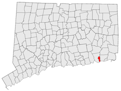
New London is a seaport city and a port of entry on the northeast coast of the United States. It is located at the mouth of the Thames River in southeastern Connecticut.
The harbor at New London is the best on Long Island Sound [3]. Connecticut College and the United States Coast Guard Academy are located on the west bank. Naval Submarine Base New London and the Electric Boat Corporation are located on the east bank in neighboring Groton.
New London was founded in 1646. It was a base of American naval operations during the Revolutionary War and was a major whaling port in the 19th century. New London Harbor is home port to the U.S. Coast Guard Cutter , the Coast Guard's tall ship Eagle, and to seventeen [4] nuclear-powered attack submarines of the U.S. Navy.
The Norwich-New London metropolitan area (NECTA [5]) includes twenty-one towns [6] and 266,618 people [7]. The population of the city of New London is 26,174 [8].
Geography
[edit]
In terms of land area, New London is one of the smallest cities in Connecticut. Of the whole 10.76 square miles (27.9 km²), nearly half is water and 5.54 square miles (14.3 km²) is land [9].
The town and city of New London are coextensive. Between 1705 and 1801 sections of the original town were ceded to form newer towns. The towns of Groton, Ledyard, Montville, and Waterford; and portions of Salem and East Lyme; now occupy what had earlier been the outlying area of New London [10].
New London is bounded on the west and north by the town of Waterford, on the east by the Thames River and Groton, and on the south by Long Island Sound.
The geographic coordinates of the state superior courthouse in New London are 41° 21' 20" N, 72° 5' 58" W [11].
Transportation
[edit]
By land, New London is practically midway between New York City and Boston. The major seaboard interstate highway, I-95, passes through the city; and New London's Amtrack station is on the passenger rail Northeast Corridor. The city of Worcester, Massachusetts is 74 miles (119 km) northward, principally via Interstate 395; and the Connecticut capital, Hartford, is 53 miles (85 km) to the northwest via a sequence of state highways.
New London is served by local taxi companies, regional Southeast Area Transit buses, interstate Greyhound Lines buses, the Cross Sound Ferry to Long Island, the Fishers Island Ferry District, and in summer by the Block Island Express ferry. The Groton-New London Airport is located in neighboring Groton; and two major airports, T. F. Green and Bradley International, are within 75 minutes driving time.
Rail freight is by the Providence & Worcester Railroad and the New England Central Railroad. Seagoing cargo at the State Pier is handled by Logistec.
