User:Na Na Utlog/sandbox
Transportation
[edit]
The transportation infrastructure in the country is relatively underdeveloped. Partly this is due to the mountainous terrain and the scattered geography of the islands, but it is also the result of the government's persistent underinvestment in infrastructure. In 2003, only 3.6% of GDP went to infrastructure development which was significantly lower than that of some of its neighbors.[1] Consequently, while there are 203,025 kilometers (126,154 mi) of roads in the country, only around 20% of the total is paved.[2]
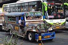
Nevertheless there are many ways to get around, especially in urban areas. Buses, jeepneys, taxis, and motorized tricycles are commonly available in major cities and towns. In 2007, there were about 5.53 million registered motor vehicles with registration increasing at an average annual rate of 4.55%.[3]
The state-owned Philippine National Railways (PNR) operates commuter rail services on a single in Metro Manila, once a day reaching Biñan, Laguna. PNR used to operate
three main railway networks that serve different areas of Metro Manila and parts of Luzon: the Manila Light Rail Transit System (LRT), the Manila Metro Rail Transit System (MRT), and the .
As an archipelago, inter-island travel via watercraft is often necessary. The busiest seaports are Manila, Cebu, Iloilo, Davao, Cagayan de Oro, and Zamboanga.[4] Passenger ships and other sea vessels such as those operated by 2GO Travel and Sulpicio Lines serve Manila, with links to various cities and towns. In 2003, the 919-kilometer (571 mi) Strong Republic Nautical Highway (SRNH), an integrated set of highway segments and ferry routes covering 17 cities was established.[5]
Some rivers that pass through metropolitan areas, such as the Pasig River and Marikina River, have air-conditioned commuter ferries. The Pasig River Ferry Service has numerous stops in Manila, Makati, Mandaluyong, Pasig and Marikina.[6] There are 3,219 kilometers (2,000 mi) of navigable inland waterways.[7]
There are 85 public airports in the country, and around 111 more that are private.[2] The Ninoy Aquino International Airport (NAIA) is the main international airport. Other important airports include the Clark International Airport, Mactan-Cebu International Airport, Francisco Bangoy International Airport and Zamboanga International Airport. Philippine Airlines, Asia's oldest commercial airline still operating under its original name, and Cebu Pacific, the leading low-cost airline, are the major airlines serving most domestic and international destinations.[8][9][10]
- ^ Cite error: The named reference
cpwas invoked but never defined (see the help page). - ^ a b World Bank. [c. 2010]. Transport in the Philippines – Overview[dead link]. Retrieved 2010-03-18 from the World Bank Website.
- ^ Republic of the Philippines. Land Transportation Office. Number of Motor Vehicles Registered. (2008-01-29). Retrieved January 22, 2009.
- ^ The Philippine Transportation System. (2008-08-30). Asian Info. Retrieved January 22, 2009.
- ^ Strong Republic Nautical Highway. (n.d.). Official Website of President Gloria Macapagal Arroyo. Retrieved January 22, 2009.
- ^ Gov't revives Pasig River ferry service. (2007-02-14). GMA News. Retrieved 2009-12-18.
- ^ Cite error: The named reference
CIAfactbookwas invoked but never defined (see the help page). - ^ "About PAL". Philippineairlines.com. Retrieved 2013-05-04.
- ^ State of Hawaii. Department of Transportation. Airports Division. [c. 2005]. "Philippine Air Lines". Hawaii Aviation. Retrieved 2010-01-09.
- ^ Oxford Business Group. (2009). The Report: Philippines 2009. p. 97. ISBN 1-902339-12-6.
{{cite book}}:|author=has generic name (help)

