User:Miriam.nh/sandbox/Infobox
Appearance
Baku
Bakı | |
|---|---|
| Nickname: | |
| Coordinates: 40°23′43″N 49°52′56″E / 40.39528°N 49.88222°E | |
| Country | |
| Government | |
| • Mayor | Hajibala Abutalybov |
| Area | |
• City | 2,130 km2 (820 sq mi) |
| Elevation | −28 m (−92 ft) |
| Population (2012)[2] | |
• City | 2,122,300 |
| • Density | 996.38/km2 (2,580.6/sq mi) |
| • Metro | 4,000,000 |
| Demonym | Bakuvian[3] |
| Time zone | UTC+4 (AZT) |
| • Summer (DST) | UTC+5 (AZST) |
| Postal code | AZ1000 |
| Area code | (+994) 12 |
| Vehicle registration | 10-90 AZ |
| Website | www |
| Official name | Walled City of Baku with the Shirvanshah's Palace and Maiden Tower |
| Type | Cultural |
| Criteria | iv |
| Designated | 2000 (24th session) |
| Reference no. | 958 |
| Endangered | 2003–2009 |
| State Party | Azerbaijan |
| Region | Europe and Asia |
Dubai
دبي | |
|---|---|
| Dubai | |
 Location of Dubai in the UAE | |
| Coordinates: 24°57′N 55°20′E / 24.950°N 55.333°E | |
| Country | |
| Emirate | |
| Founded by | Rashid bin saeed Al Maktoum |
| Seat | Dubai |
| Subdivisions | |
| Government | |
| • Type | Constitutional monarchy[4] |
| • Emir | Mohammed bin Rashid Al Maktoum |
| • Crown Prince | Hamdan bin Mohammed bin Rashid Al Maktoum |
| Area | |
• Total | 4,114 km2 (1,588 sq mi) |
| Population (1 January 2013) | |
• Total | 2,106,177 |
| • Density | 524.7/km2 (1,359/sq mi) |
| • | 53% Indian 17% Emirati 13.3% Pakistani 7.5% Bangladeshi 2.5% Filipino 1.5% Sri Lankan 0.3% American 5.7% other countries |
| Time zone | UTC+4 (UAE Standard Time) |
| GDP | US$ 82.9 billion [6] |
| GDP per capita | US$ 24,866 [6] |
| Website | Dubai Emirate Dubai Municipality Dubai Tourism |
London | |
|---|---|
   | |
 | |
| Coordinates: 51°30′26″N 0°7′39″W / 51.50722°N 0.12750°W | |
| Sovereign state | |
| Country | |
| Region | London |
| Administrative area | Greater London |
| Settled by Romans | c. 43 AD (as Londinium) |
| Ceremonial counties | City & Greater London |
| Districts | City & 32 boroughs |
| Government | |
| • Body | Greater London Authority |
| • Legislature | London Assembly |
| • Mayor | Boris Johnson |
| • London Assembly | 14 constituencies |
| • UK Parliament | 74 constituencies |
| • European Parliament | London constituency |
| Area | |
| • Greater London | 1,572.00 km2 (606.95 sq mi) |
| • Urban | 1,737.9 km2 (671.0 sq mi) |
| • Metro | 8,382.00 km2 (3,236.31 sq mi) |
| Elevation | 35 m (115 ft) |
| Population (2013)[8]
| |
| • Greater London | 8,416,535 |
| • Density | 5,354/km2 (13,870/sq mi) |
| • Urban | 9,787,426 |
| • Metro | 13,614,409 |
| Demonym | Londoner |
| Time zone | GMT (UTC) |
| • Summer (DST) | UTC+1 (BST) |
| Postcode areas | |
| Area code |
|
| GeoTLD | .london |
| Website | london.gov.uk |
Kuwait City
مدينة الكويت Madinat Al Kuwayt | |
|---|---|
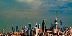
 The Skyline of Kuwait City | |
| Nickname: مدينة | |
| Coordinates: 29°22′11″N 47°58′42″E / 29.36972°N 47.97833°E | |
| Country | Kuwait |
| Governorate | Al Asimah |
| Area | |
| • Metro | 200 km2 (80 sq mi) |
| Population (2014 estimate) | |
• City | 637,411 |
| • Metro | 2,380,000 |
| Time zone | UTC+3 (AST) |
Paris | |
|---|---|
 Clockwise from top: Pyramid of the Louvre, Arc de Triomphe, Palace of Versailles, skyline of Paris on the River Seine with the Pont des Arts bridge, and the Eiffel Tower - clickable image | |
| Motto(s): | |
| Coordinates: 48°51′24″N 2°21′03″E / 48.8567°N 2.3508°E | |
| Country | France |
| Region | Île-de-France |
| Department | Paris |
| Subdivisions | 20 arrondissements |
| Government | |
| • Mayor (2014-present) | Anne Hidalgo (PS) |
Area 1(2010)[9] | 105.4 km2 (40.7 sq mi) |
| • Urban (2010) | 2,844.8 km2 (1,098.4 sq mi) |
| • Metro (2010) | 17,174.4 km2 (6,631.1 sq mi) |
| Population (2013[10]) | 2,273,305 |
| • Rank | 1st in France |
| • Density | 22,000/km2 (56,000/sq mi) |
| • Urban (2014) | 12,005,077[11] |
| • Metro (Jan. 2009) | 12,161,542[12][13] |
| Demonym(s) | Parisian (en) parisien(ne) (fr) |
| Time zone | UTC+01:00 (CET) |
| • Summer (DST) | UTC+02:00 (CEST) |
| INSEE/Postal code | 75056 /75001-75020, 75116 |
| Website | www.paris.fr |
| 1 French Land Register data, which excludes lakes, ponds, glaciers > 1 km2 (0.386 sq mi or 247 acres) and river estuaries. | |
Santurtzi | |
|---|---|
| Santurce | |
 | |
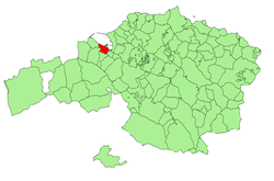
 Location of Santurtzi in Biscay. | |
| Coordinates: 43°19′49″N 03°1′53″W / 43.33028°N 3.03139°W | |
| Country | |
| Autonomous community | |
| Province | Biscay |
| Comarca | Greater Bilbao |
| Founded | 1075, first written reference |
| Government | |
| • Alcalde | Ricardo Ituarte (PNV) |
| Area | |
• Total | 6.77 km2 (2.61 sq mi) |
| Elevation | 2 m (7 ft) |
| Population (2009) | |
• Total | 46,978 |
| • Density | 6,900/km2 (18,000/sq mi) |
| Demonym(s) | Santurzano, santurtziarra (eusk.) |
| Time zone | UTC+1 (CET) |
| • Summer (DST) | UTC+2 (CEST) |
| Postal code | 48980 |
| Official language(s) | Basque |
| Website | Official website |
- ^ "Administrative, density and territorial units and land size by economic regions of Azerbaijan Republic for January 1. 2007". Archived from the original on 24 November 2007. Retrieved 17 July 2009.
- ^ The State Statistical Committee of the Republic of Azerbaijan, 2.5 Population by sex, economic and administrative regions, urban settlements at the beginning of 2012, retrieved on October 2, 2012
- ^ Thomas de Waal (2010). The Caucasus: An Introduction. Oxford University Press. p. 16. ISBN 978-0199750436.
- ^ "UAE Constitution". Helplinelaw.com. Retrieved 21 July 2008.
- ^ Area of "Dubai emirate", includes artificial islands.
- ^ a b "Global city GDP 2014". Brookings Institution. Retrieved 18 November 2014.
- ^
"London, United Kingdom Forecast : Weather Underground (weather and elevation at Bloomsbury)" (online). The Weather Underground, Inc. Retrieved 22 August 2014.
{{cite journal}}: Cite journal requires|journal=(help)CS1 maint: url-status (link) - ^ "UK Population Estimates". ONS. 26 June 2014. Retrieved 26 June 2014.
- ^ INSEE local statistics, including Bois de Boulogne and Bois de Vincennes.
- ^ Cite error: The named reference
pop2013was invoked but never defined (see the help page). - ^ INSEE, Government of France. "Unités urbaines de plus de 100 000 habitants en 2011" (in French). Retrieved 27 January 2015.
{{cite web}}: Check|first=value (help) - ^ "Aire urbaine 2010 : Paris (001)". INSEE. Retrieved 21 October 2011.
- ^ "Aire urbaine 2010 : Paris (001)" (in French). INSEE. Retrieved 3 July 2012.


