User:MSG17/List of expressways in Japan
| This is not a Wikipedia article: It is an individual user's work-in-progress page, and may be incomplete and/or unreliable. For guidance on developing this draft, see Wikipedia:So you made a userspace draft. Find sources: Google (books · news · scholar · free images · WP refs) · FENS · JSTOR · TWL |
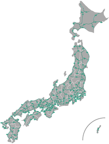
The expressways of Japan consist of a multitude of controlled-access highways, often tolled, that are part of several systems.
National expressways
[edit]
National expressways (高速自動車国道, Kōsoku Jidōsha Kokudō) make up a system of expressways that serve the whole country. They mostly facilitate intercity travel, with some being orbital routes around urban areas. As of 2018, there are 11,520 km (7,160 mi) of expressways operational, with the overwhelming majority of that length being tolled.[1]
Privately operated
[edit]
The privatization of Japan Highway Public Corporation in 2005 has caused a majority of Japan's expressways and tool roads to be operated by the companies collectively referred to as NEXCO (Nippon Expressway Company).
| Name and number | Tokyo-bound terminus | Other terminus | Length | Opened |
|---|---|---|---|---|
Tokyo-Gaikan Expressway |
Setagaya, Tokyo | Ichikawa, Chiba | 33.7 km (20.9 mi) | 1992 |
| Name and number | Tokyo-bound terminus | Other terminus | Length | Opened |
|---|---|---|---|---|
Mei-Nikan Expressway |
Nagoya-minami Junction, Nagoya |
Nagoya-nishi Junction, Nagoya |
43.7 km (27.2 mi) | 1988[2] |
| Name and number | Tokyo-bound terminus | Other terminus | Length | Opened |
|---|---|---|---|---|
Meishin Expressway |
Komaki, Aichi |
Nishinomiya, Hyōgo |
193.9 km (120.5 mi) | July 16, 1963 |
Honshū-Shikoku Bridge Expressway Company
[edit]The Honshū-Shikoku Bridge Expressway Company operates three expressways that connect the islands of Honshu and Shikoku, as well as the system of bridges that these expressways use to cross the Seto Inland Sea.
| Name and number | Tokyo-bound terminus | Other terminus | Length | Opened | Notes |
|---|---|---|---|---|---|
Kobe-Awaji-Naruto Expressway |
Nishi-ku, Kobe | Naruto, Tokushima | 89 km (55 mi) | 1985 | |
Seto-Chūō Expressway |
Kurashiki, Okayama |
Sakaide, Kagawa |
89 km (55 mi) | 1988 | |
Nishiseto Expressway |
Onomichi, Hiroshima |
Imabari, Ehime |
89 km (55 mi) | 1979 2006 |
Publicly operated
[edit]MLIT
[edit]The Ministry of Land, Infrastructure, Transport and Tourism owns some national expressways as part of the Japanese government.
Prefectural routes
[edit]Urban expressways
[edit]Some metropolitian areas in Japan have their own expressways for intra-city travel that are separate from the national network.
Fukuoka & Kitakyūshū
[edit]While both networks are managed separately and aren't physically connected to each other, both are managed by the Fukuoka-Kitakyushu Expressway Public Corporation.
Keihanshin (Kyoto-Osaka-Kobe)
[edit]Hiroshima
[edit]Nagoya
[edit]Tokyo
[edit]References
[edit]- ^ Ministry of Land, Infrastructure and Transport. "Roads in Japan 2018" (PDF). Retrieved 2019-11-10.
- ^ Ministry of Land, Infrastructure and Transport. "History of the Expressway Network in the Greater Nagoya Area" (in Japanese). Archived from the original on 28 March 2008. Retrieved 29 June 2019.
External links
[edit]

