User:Lesalmin~enwiki/sandbox
Serfaus | |
|---|---|
 Location within Tyrol | |
| Coordinates: 47°02′19″N 10°36′21″E / 47.03861°N 10.60583°E | |
| Country | Austria |
| State | Tyrol |
| District | Landeck |
| Government | |
| • Mayor | Paul Greiter |
| Area | |
| • Total | 59.6 km2 (23.0 sq mi) |
| Elevation | 1,429 m (4,688 ft) |
| Population (1 January 2016)[1] | |
| • Total | 1,127 |
| • Density | 19/km2 (49/sq mi) |
| Time zone | UTC+1 (CET) |
| • Summer (DST) | UTC+2 (CEST) |
| Postal code | 6534 |
| Area code | 05476 |
| Vehicle registration | LA |
| Website | www.serfaus.gv.at |
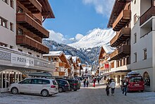
Serfaus on kylä Itävallassa Tirolin osavaltiossa.
Maantiede
[edit]Serfaus on kylä Inn-joen laakson ylätasangolla Tirolissa, Itävallassa. Kylä muodostaa yhdessä kahden naapurikylänsä Fissin ja Ladisin kanssa Serfaus-Fiss-Ladisin hiihtoalueen. Serfaus on tunnettu pienestä kylämetrostaan (Dorfbahn). Vain 1280 m pitkän radan ainoa juna kuljettaa pääasiassa talvisin laskettelijoita autottoman kylän ali sen alapäässä olevalta pysäköintialueelta yläpäässä olevan köysiradan ala-asemalle pysähtyen kahdella väliasemalla. Moottoriajoneuvoliikenne on periaatteessa kylän alueella kielletty, mutta käytännössä liikennettä on melko paljon johtuen huolto- ja jakeluliikenteestä sekä hotellivieraista, joilla on oikeus ajaa majapaikkansa pihaan.
Historia
[edit]Serfausin alueen varhaisimmat asutuslöydökset ajoittuvat pronssikaudelle. 3200 vuotta vanhan tulisijan jäännökset korkealla alppiniityllä Komperdelissa osoittavat, että aluetta käytettiin jo tuolloin laiduntamiseen tai metsästykseen. Zienerbichlin alueen arkeologisissa tutkimuksissa on löydetty myöhäisiantiikkisia sekä keskiaikaisia jäännöksiä.
Pre-Roman field names and some Celtic traces still hint at the early settlers in this region. Ancient historians described the area as Raetia and its inhabitants as Raeti. However, with the conquest of the area by the Romans about 15 BC the Roman and Raetic cultures began to mix, creating the Romansh people. The Romansh language, which is still spoken in some parts of the Swiss Canton Graubünden, has survived in many of the regional field names. In the 6th century the German speaking Bavarii started to inhabit the plateau, gradually extruding the Romansh from day to day language.
Ensimmäiset viralliset viittaukset itse kylään ajoittuvat 11. vuosisadalle, jolloin Seen ja Kapplin kylät Paznaunin laaksossa oli perustettu osittain Serfausin alueelle. Vuoteen 1891 See oli osa Serfausin kirkonkylää, mistä johtuen Serfausissa on edelleen hautausmaa Seen asukkaille.
Other important cultural landmarks include the pilgrimage church of St. Georgen. Built in the Middle Ages it is one of the oldest churches in the region.
During the 19th century tourism started to flourish in Tyrol and after the Second World War, tourism became the main source of income for the village.
1942 fourteen houses were destroyed by a fire, which left 16 families (a total of 89 people) without home and caused a damage of about 650.000 Reichsmark. The village was rebuilt after the Second World War, also allowing the new buildings more space in contrast to the old structure of a clustered romansh village.
To cope with the increase of traffic due to a growing tourism in the region, Serfaus banned private traffic in winter in the 1970s. For the transportation of guests (and especially Skiers) a bus service was established. In order to enable an even quieter and more environmentally friendly way of transportation, the subway system, the Dorfbahn Serfaus went into operation in 1985. The use of the underground is free of charge and over its course of 1280 m it has 4 stopps (Parkplatz, Kirche, Raika, Seilbahn) and can transport up to 1500 people per hour.
Matkailu
[edit]
As Serfaus is close to the Via Claudia Augusta and the Reschen Pass people are thought to have traveled through the area for hundreds of years. Moreover the marian pilgrimage which has been taking place since the Middle Ages has caused some travel to and from the mountain village. The Theresian Cadasdre of 1776 lists Johannes Penz with the "right to operate a tavern". By 1812 the inhabitants of Serfaus were asked to pay an extra tax for the loging of foreigners in their taverns of private rooms. This shows that tourism was already present at these times, even if still only in its most basic form.
Shortly after 1900 Skiers started to discover the possibilities in the region and in 1912 plans were made to build a little ski hut on one of the high alpine meadows surrounding the village, the "Kölnerhaus" up at the "Komperdell". However during the First World War and the following 1920s the tourism developed very slowly. Tourism between the two world wars reached its peak in 1931/32 with 30,000 registered guests. As a result the three taverns could not provide enough accommodation anymore and farmers started to rent out private rooms to guests of the region. Thus Serfaus had 150 registered beds in 1930. 1940 cable car for transporting goods to the "Kölnerhaus" was installed and was turned into an aerial tramway seating five people, in 1951. This caused a new increase of tourism in Serfaus and through the constant renewal and expansion of the infrastructure and the connection to the lifts of Fiss-Ladis the ski area now covers 190 km of pistes through 70 lifts. Today the town is one of the most popular ski and holiday areas in Tyrol.[2]
Lähteet
[edit]- ^ Statistik Austria - Bevölkerung zu Jahresbeginn 2002-2016 nach Gemeinden (Gebietsstand 1.1.2016) for Serfaus.
- ^ Klien, R., Tschuggmall, A., Klien, G.R. (2002) "Der Tourismus", in Klien, Robert, Serfaus, (Serfaus 2002), p. 445 - 461.


