User:J Clear/sandbox
Appearance
{{Geobox|Settlement}}
Mont Clare
formerly Quincyville | |
|---|---|
Village | |
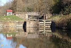
 Schuylkill Canal Lock 60 in Mont Clare | |
| Coordinates: 40°08′10″N 75°30′24″W / 40.13611°N 75.50667°W | |
| Country | United States of America |
| State | Pennsylvania |
| County | Montgomery |
| Township | Upper Providence |
| Named for | Mont Clare/Clair Estate from poet Bayard Taylor |
| Government | |
| • Type | Unincorporated Village |
| Area | |
| • Land | 0.659 sq mi (1.71 km2) |
| • Water | 0.047 sq mi (0.12 km2) |
| [1] | |
| Population (1990)[2] | |
• Total | 1,800 |
| Time zone | UTC-5 (Eastern Standard Time) |
| • Summer (DST) | UTC-4 (Eastern Daylight Time) |
| ZIP Code | 19453 |
| Area code(s) | 610, 484 |
| GNIS feature ID | 1181444 |
- ^ US 2010 Census data
- ^ Cohen, Saul B., ed. (2000). The Columbia Gazetteer of North America. New York: Columbia University Press. ISBN 0-231-11990-9. Archived from the original on 25 March 2005.
{{cite book}}: Cite has empty unknown parameter:|coauthors=(help)


